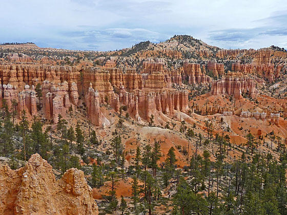
Fairyland Canyon
This terrific loop hike travels along the rim and then into Fairyland and Campbell Canyons with amazing views of multi-colored hoodoos, spires and fins. This path is more strenuous but less crowded than Bryce National Park’s other trails.
See Trail Detail/Full Description
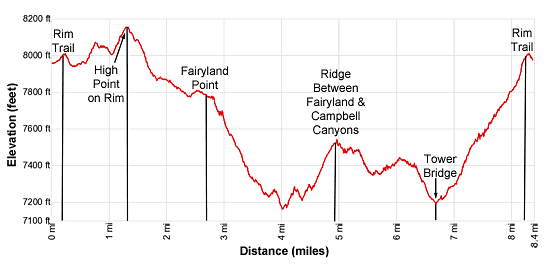
- Distance: 8.4 miles (round trip) to Fairyland Loop
- Elevation: 7,980-ft. at Trailhead
8,150-ft. at Fairyland Loop - Elevation Gain: 1,320-ft. to Fairyland Loop
- Difficulty: moderate
- More Hikes in:
Bryce / South Central Utah
Why Hike Fairyland Loop
Hike through a wonderland of weird and whimsical rock formations on this great loop hike in the northern end of the park that incorporates a segment of the Rim Trail with paths through Fairyland and Campbell Canyons. The rim section of the hike features views of multi-hued hoodoos, spires and fins jutting from ledges and ridges along the canyon rim as well as views of Boat Mesa, Bristlecone Point and Bryce Point.
At Fairyland Point the trail descends into Fairyland Canyon, where the formations are younger than those to the south in the main Bryce Amphitheater. Here the trail wanders through a maze of colorful hoodoos and spires. Larger eroded formations along the main wall of the canyon resemble castles, cathedrals and fortresses.
In contrast, the return leg of the loop ascends Campbell Canyon, an area where the hoodoos and fins have eroded into mounds and less defined shapes than seen on the Fairyland section of the hike. Here you will see Tower Bridge, a natural bridge flanked by two spires and a window, along with the Chinese Wall, a beautiful fin finely sculpted by wind and water into photogenic towers and columns adorn with small windows. This segment includes an extended walk along a ridge crest featuring wide ranging views of the park.
This loop hike is considered more strenuous than the other hikes in the park and is therefore less crowded. Take plenty of water and remember that the end of the hike gains over 850-ft. in 1.6 miles as it climbs back to the rim. This is a very hot hike during the height of the summer.
Elevation Profile
Trail Resources
Trail Detail/Full Description / Trail Photo Gallery / Trail Map
Basecamp(s) Information:
Bryce
Region Information:
South Central Utah
Other Hiking Regions in:
Utah