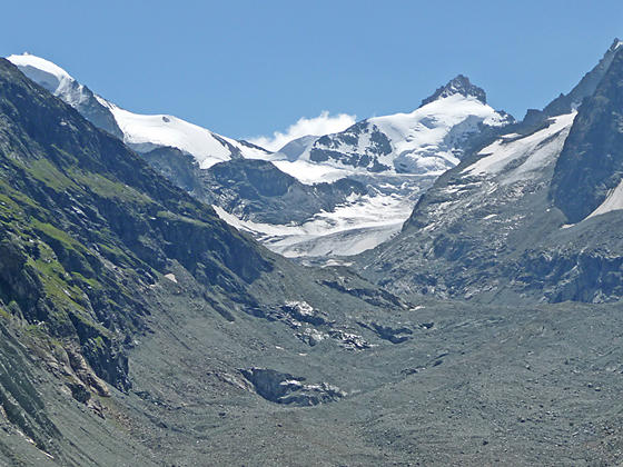
Mont Durand, Ppinte de Zinal and the Zinal Glacier
This trail offers a good perspective of the Zinal Valley, ascending through forests and meadows before climbing the slopes of an old moraine to the Cabane du Peitit Mountet. The hut features fine views of the Zinal Glacier and the ice-clad peaks rimming the upper Zinal Valley.
- Distance: 6.6 - 8.0 miles (RT)
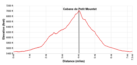
- Elevation: 5,450-ft. at Trailhead
Maximum elevation - 7,028-ft. - Elevation Gain: 1,578-ft.
- Difficulty: moderate
- Basecamp: Zinal
- Region: The Valais
Trail Description - Cabane du Petit Mountet
This hike starts on Zinal's (5,479-ft.) main street. (See trailhead directions below.) Walk south (up valley) along the main street to a car park at 0.6 miles. Turn right (west) and cross the wood bridge over the La Navisence River, the river draining the Zinal Valley. On the west side of the river turn left (south) and continue walking up the Zinal valley toward the Petite Mountet (1-hr 50-min) and Grand Mountet (4-hr 10-min). The broad track ascends through pastures on easy grades with nice views of Besso (12,001-ft.) towering above the east side of the valley.
Pass a junction at 1.7 miles with a route branching left toward Lac Arpitetta and the Arpitetta Hut. Our track continues south and soon starts ascending on moderately-steep grades through meadows and scattered trees.
At 2.2 miles the trail travels by a pretty waterfall and then climbs a switchback. Soon the path reaches a junction at Le Vichiesso (6,109-ft.). Here a path branches right toward the Petit Mountet (45-min). This is a shorter, steeper trail to the hut that we will take on the return leg. For now, stay on the main track toward Petit Mountet (1-hr), Grand Mountet (3-hr 20-min) and the Arpitetta Hut.
The grade eases as the trail passes a small building at 2.5 miles. La Navisence tumbles down the rocky riverbed below the trail.
Reach a junction at 2.9 miles. Continue straight ahead toward the Petit Mountet. The trail to the left (east) crosses the river and heads toward the Grand Mountet. To the east are great views of a waterfall cascading down rocky slopes beneath the Pointe de Arpitetta.
The trail now climbs on moderate to moderately-steep grades up a brushy hillside atop the remains of any old lateral moraine wall. The Navisence River rushes down a rock streambed beside the trail. At 3.3 miles the grade steepens as the trail climbs switchbacks up the hill. As you climb enjoy ever improving views of the Pointe de Zinal, a triangular peak, at the head of the valley. Besso and the Grand Cornier tower above the massive trench dug by the retreating Zinal Glacier. As you gain altitude Mont Durand joins the scene. To the east are fine views of the Pointe de Arpitetta, the Weisshorn and neighboring giants rimming the eastern wall of the Zinal Valley.
Reach the Cabane du Petit Mountet (7,028-ft.) at 4.0 miles. The cabane, sitting atop the eroding moraine, features great views of the glaciers clinging to the high peaks at the head of the valley. The Zinal Glacier, covered by debris, flows down the valley floor. Besso looms above the valley to the east while the Grand Cornier dominates the view to the west. Below the hut the Navisence flows along the valley floor, littered with debris from the retreating glacier.
The Cabane offers drinks, meals and dormitory accommodations. From the Cabane it is possible to walk a short distance along the moraine crest to an overlook for more panoramic views. Don’t go beyond the sign marking the end of the overlook. The moraine is extremely eroded, unstable and not safe for travel beyond the sign.
When you are done admiring the views, retrace your steps to the trailhead for an 8.0 mile round trip hike. Alternatively, take the shorter, steeper trail back. To find the alternative trail, walk a short distance down the hill from the hut. At the first switchback (hairpin curves where the main trail turns right) take the narrow trail, signed for Zinal, straight ahead (north). The rocky trail descends through bushy meadows on steep to moderately-steep grades to the junction we passed on the trip up the valley, shaving 0.7 miles off the return journey. At 5.1 miles the alternate trail rejoins the broad track heading back to Zinal for a 7.3 mile hike.
This is a good hike for families or hikers trying to acclimate. The trail is also a good option when the weather precludes travel in the high country.
Elevation Profile
Driving Directions
Directions in Zinal: From the Post Office/Bus stop in Zinal, walk south along Rue des Cinque 4000 (the town’s main street). The mileage in this description starts the hike a few blocks beyond, near the tennis courts and ice skating rink. Add 0.3 miles (round trip) to the hike if starting from the bus stop.
From Grimentz to Zinal: From one of several bus stops in Grimentz, board the bus to Zinal and get off at the Zinal post office stop. If possible catch a direct bus to Zinal. Otherwise, take the Vissoie Bus to Vissoie where you will need to change for a bus headed up the valley to Zinal. The direct buses take 15 minutes. If you need to change in Vissoie the ride will take 58 minutes or longer.
Buses make several stops in Grimentz. Schedules are posted at the bus stops. Departure times are also available online at the SBB website and the SBB app.
Trail Resources
- Trail Photo Gallery
- Trail Maps
- Basecamp(s) Information: Zinal
- Region Information: The Valais
- Other Hiking Regions in: Switzerland