Governor Basin 
Distance: 5.8 - 7.6 miles (round trip)
Uncompahgre National Forest, near Ouray in Southwest Colorado
Potosi and Teakettle
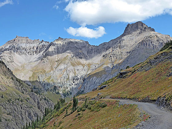
Ascend a scenic jeep road into the heart of Governor Basin, explore the Mountain Top mine ruins and then follow a route to an overlook with impressive views of the high peaks of Yankee Boy Basin.
See Trail Detail/Full Description
- Distance: 5.8 miles (round trip) to Governor Basin
7.6 miles (round trip) to Overlook - Elevation: 10,715-ft. at Trailhead
11,990-ft. at Governor Basin
12,800-ft. at Overlook - Elevation Gain: 1,275-ft. to Governor Basin
2,085-ft. to Overlook - Difficulty: moderate-strenuous
- More Hikes in:
Ouray / Southwest Colorado
Why Hike Governor Basin
I don’t often recommend hikes on jeep roads, but I make an exception for Governor Basin. The hike is highly scenic and includes a visit to the Mountain Top Mine, where the ruins of a multi-story wood dormitory. Beyond the jeep road a route climbs to a high overlook with breathtaking views of Mount Emma, the San Sophia Ridge, Cirque Mountain, Teakettle Mountain, Potosi Peak and beyond. During late July and early August the meadows of Governor Basin are awash in a magnificent display of wildflowers.
With adequate time, energy and good weather it is possible to explore beyond the viewpoint, scrambling up nearby ridges for views that extend to Mount Sneffels and/or the Telluride area. The area also provides access to Mount Emma, although this class 4 scramble is best left to experienced climbers.
I strongly advise getting an early start on this hike to beat afternoon thunderstorms, a frequent occurrence in area, and to avoid the bulk of the jeep traffic on the road. Hiking the road on a week day, when Jeep traffic is typically lighter, is also a good idea. Avoid the hike during the Ouray Jeep Rally and holiday weekends.
Elevation Profile
| Buy the BookThis opinionated guide includes all the hikes in the Ouray, Telluride, Silverton and Lake City sections of the website plus info on local services and nearby attractions. |
Trail Resources
Trail Detail/Full Description / Trail Photo Gallery / Trail Map
Basecamp(s) Information:
Ouray
Region Information:
Southwest Colorado
Other Hiking Regions in:
Colorado