Details: Cohab Canyon to Cassidy Arch via the Fryingpan 
Distance: 6.0 - 8.6 miles (round trip)
Fruita District, Capitol Reef National Park, near Capitol Reef in South Central Utah
Hike Facts
- Distance: 6.0 - 8.6 miles (round trip)
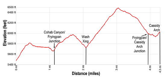
- Elevation: 5,480-ft. - 6,490-ft.
- Elevation Gain: 1,600-ft.
- Difficulty: strenuous
- Trail Highlights: See Trail Intro
- Basecamp(s): Capitol Reef
- Region: South Central Utah
Terrific panoramas atop Waterpocket Fold, a scenic canyon and a photogenic arch are the highlights of this amazing, albeit strenuous hike through a rugged landscape that incorporates portions of the Cohab Canyon, Fryingpan and Cassidy Arch trails.
Cohab Canyon to Cassidy Arch via the Fryingpan Trail
From the Fruita parking area (see driving directions below), walk a short distance southeast along Scenic Drive to the Cohab Canyon trailhead, located on the left (east) side of the road. The trail immediately starts gaining elevation, climbing steep switchbacks with great views of the Fruita Area and the red rock cliffs towering above the north side of the Fremont River and Highway 24.
After 0.25 miles the grade eases a bit as the trail turns right (south) and travels along sheer Wingate cliffs to the head of Cohab Canyon, a hanging valley. After going over a minor hump the trail drops into Cohab Canyon on easy grades.
The narrow canyon’s terracotta and beige walls are highly eroded and in place look like geologic Swiss cheese. Initially the trail travels down the sandy wash scattered with junipers and pinyon pines. At 0.7 miles the canyon widens. Soon the trail leaves the wash and travels on slickrock along the left (north) side of the canyon.
At 1.0 mile reach a junction. To the left is a trail that climbs the canyon’s north wall and then spits after 0.3 miles with one branch going right (north) to an overlook with views of the Fremont River Canyon in 0.1 miles and the other heading left (southwest) to an overlook with views of the Fruita area in 0.2 miles.
I recommend bypassing the overlooks and saving your energy for the rest of the trail. The overlooks, while nice, pale in comparison to the vistas you will see along the Fryingpan trail.
At the junction continue straight ahead down Cohab Canyon toward Utah Highway 24. The path now drops into the wash and then climbs a short distance up the canyon’s south wall to a second junction. The trail to the left continues along a bench above the south side of Cohab Canyon to Highway 24. We take the Fryingpan Trail to the right (southwest) toward Cassidy Arch and the Grand Wash.
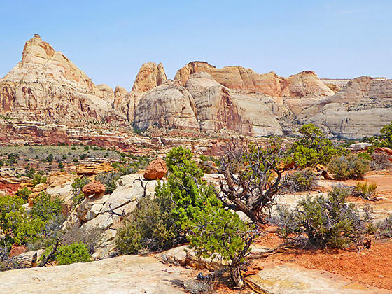
A short steep climb out of the canyon soon leads to a bench where the grade moderates and views open to an incredible landscape of massive domes and blocks above the north side of the Fremont Valley. You are now atop Waterpocket Fold, a rugged corrugated landscape of multi-hued cliffs, knolls and domes scattered with junipers and pinyon pines.
Initially the trail heads southwest, ascending along the bench above the south side of Cohab Canyon. The trail surface varies between packed dirt and sections of slickrock, marked by rock cairns. At 1.5 miles the trail curves to the southeast and starts climbing a series of ledges up to a ridgetop separating two drainages.
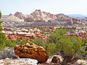
The ridgetop features a great perspective of the tilted cliffs and Navajo sandstone formations of the Waterpocket Fold to the north. Nearer at hand is an interesting standing rock formation with a massive red boulder balanced atop an eroding white sandstone column.
From the ridge the trail descends on moderately steep grades on a circuitous route weaving around sandstone knolls and boulders and dropping down slickrock ledges. Ahead are views of the formations in the heart of Capitol Reef including the aptly named Fern’s Nipple. After losing above 250-ft. the trail crosses a shallow, sandy wash at 2.1 miles. A short distance to the west is a pour-off dropping into a deep canyon.
The path now curves to the right (southwest) and ascends on steep to moderately-steep grades up fractured slickrock ledges to a bench. As you climb enjoy fine views of the formation to the north/northeast. The ascent continues along the bench with terrific views to the north and west.
At 2.9 miles the trail curves to the left (east) and climbs to the high point (6,490-ft.) on the Fryingpan Trail at 3.0 miles. Here we enjoy amazing views of Waterpocket Fold to the north, where massive Navajo sandstone formation set atop colorful, tilted cliffs. To the northeast Ferns Nipple and the nearby blocks and domes command your attention. Boulder Mountain fills the skyline to the southwest while Thousand Lakes Mountain and Plateau forms the backdrop for a sea of red sandstone formations to the northwest.
When you are done taking in the views, follow the trail as it descends southeast on moderate to easy grades. Ferns Nipple is directly in front of you. At 3.6 miles the trail reaches the edge of the cliff towering above Scenic Drive. Views open to the Grand Wash Road and the red rock landscape beyond.
The path now curves to the left (east/northeast) and begins a steep to moderately-steep descent to the Cassidy Arch trail with views of photogenic sandstone formations tower above the landscape to the east and southeast.
Reach a junction marking the end of the Fryingpan Trail at 3.9 miles. Turn right onto the Cassidy Arch Trail toward the arch. The trail to the left descends the Cassidy Arch trail to the Grand Wash Trail. The cairned route now curves around to the right to circumvent a deep chasm and then turns left (south) on an undulating trail ascending across a slickrock expanse. Toward the end of the trail the route descends slightly to a spot where you can look down upon Cassidy Arch at 4.3 miles.
The arch, situated in a deep cavity, is named after Butch Cassidy, who is thought to have used Grand Wash as a hide out on occasion. Use care around the sheer drop-offs at the edge of the cavity.
When you are done admiring the arch, walk 0.4 miles back to the junction. With a previously arranged car shuttle you can hike down the Cassidy Arch trail to the trailhead at Grand Wash, losing 670-ft. in 1.3 miles for a 6.0 mile point to point hike. Alternatively, retrace your steps to the Cohab Canyon Trailhead for an 8.6 miles round-trip hike.
Don’t under estimate the strenuous nature of this trail. There are plenty of ups and downs making it more tiring than the net elevation gain implies. Given its length and difficulty, the trail is best hiked in the Spring or Fall when temperatures are cooler. Remember to take plenty of water, you will find none along the trail.
Note: Rock cairns mark much of the route as it twists around low knolls, crosses drainages and navigates around a variety of obstacles. It is essential to pay attention to the rock cairns to stay on track. If you are not experienced traveling on cairned trails, try a few other hikes in the park first before tackling this outing.
Elevation Profile
Driving Directions
Capitol Reef Visitor Center to Cohab Canyon Trailhead: Turn right out of the Visitor Center on Campground Road and drive for 1.0 miles to the large parking area on the left (east). Along the way Campground Road turns into Scenic Drive. Park in the lot and then walk 0.1 mile south on Scenic Drive to the Cohab Canyon trailhead, located on the left (east) side of the road. Along the way you will pass the Gifford Homestead and the Fruita Barn.
Capitol Reef Visitor Center to Grand Wash Trailhead: Turn right out of the Visitor Center on Campground Road/Scenic Drive. Follow Scenic Drive for 3.4 miles and then turn left onto Grand Wash. Drive 1.3 miles on the Grand Wash, a good dirt road, to the Cassidy Arch trailhead parking area, located on the left side of the road.
Trail Resources
Trail Intro / Trail Photo Gallery / Trail Map
Basecamp(s) Information:
Capitol Reef
Region Information:
South Central Utah
Other Hiking Regions in:
Utah