Lauterbrunnen to Trummelbach Falls 
Distance: 2.2 miles
Bernese Oberland, near Lauterbrunnen in The Bernese Oberland
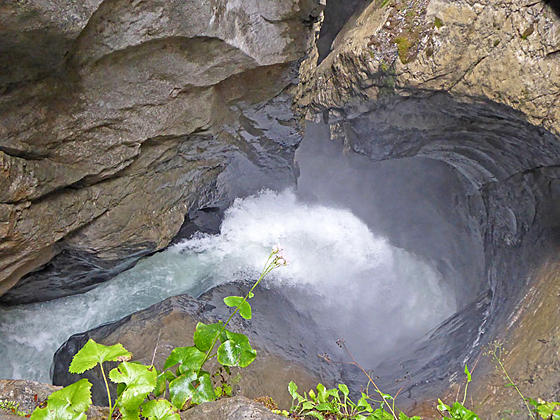
Waterfall at Trummelbach Falls
This lovely walk up the Lauterbrunnen Valley travels through emerald green meadows and passes photogenic waterfalls on the way to Trummelbach Falls, a World Heritage Site. The dramatic falls are a true natural wonder, showcasing a series of waterfalls thundering down a slot canyon carved into a mountain.
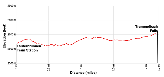
- Distance: 2.2 miles (One Way)
- Elevation: 2,610-ft. at Trailhead
Maximum elevation - 2,720-ft. - Elevation Gain: 110-ft.
- Difficulty: easy
- Basecamp: Lauterbrunnen
- Region: The Bernese Oberland
Trail Description - Lauterbrunnen to Trummelbach Falls
The Lauterbrunnen Valley is said to have 72-waterfalls. I’ve not seen that many but the number of magnificent waterfalls along the valley is quite impressive. This hike visits two of the most famous falls; Staubbach Falls, located at the southwest end of Lauterbrunnen, and Trummelbach Falls, a World Heritage site and the destination for this hike.
Trummelbach Falls, Europe’s largest subterranean waterfalls, channels meltwater from the Jungfrau glacier down a slot canyon carved deep into the mountain. Constant abrasion of glacial debris in the water formed, and continues to shape, the canyon's highly sculpted walls. A funicular, walkways and stairs deep in the mountain permit visitors to access ten viewpoints where waterfalls plummets down chutes, spill through narrow passages and corkscrews down narrow slots. Mist fills the air around the viewpoints.
The falls is definitely worth a visit. Most people take the bus from the Lauterbrunnen Train Station to Trummelbach Falls. My preference is to walk from Lauterbrunnen to Trummelbach, a 2.2 mile hike. The lovely walk heads up the Lauterbrunnen Valley, traveling through pretty pastures and passing small alps. Waterfalls spill down the sheer cliffs along both sides of the valley. If time and energy permit, retrace your steps to Lauterbrunnen for a 4.4 mile hike.
This walk can be done in any weather. On a nice day the brilliant blue skies and emerald green meadows contrast beautifully with the peaks, adorn with glistening glaciers, at the head of the valley. My favorite time to do this hike is on a rainy day. Clouds will probably obscure views of the high peaks but you will see an amazing number of waterfalls in all their glory, pouring from overhangs and splashing down rugged cliff faces.
Lauterbrunnen to Trummelbach Falls
From the train station in Lauterbrunnen, walk south along the main street. At 0.3 miles, just before the street makes a sharp left turn, bear right on a side road. The turn is marked by yellow trail signs on a post pointing toward the Trummelbach Hotel and Stechelberg. There is also a sign pointing toward the Jungfrau campground. As you walk down the road you will pass the Horner Pub and then a large parking lot on your left.
You are now heading up the Lauterbrunnen valley, a classic “U” shaped glaciated valley lined with sheer rock walls. On your right the dramatic 975-ft. Staubbach Falls freefalls down a sheer cliff to the valley floor. At 0.5 miles a short spur trail climbs to the base of the falls, a worthwhile detour for anyone who would like to get an up-close shot of the waterfall.
Past Staubbach Falls you will pass a few houses and then a campground on your left. At all intersections continue heading south on the road. Beyond the campground the trail travels through pastures and small alps with views of more waterfalls tumbling down the walls on both sides of the valley. Straight ahead are fine views of the Breithorn towering above the head of the valley.
Reach Buchen at 1.5 miles and turn left on a signed path for Trummelbach Falls. The trail heads east through pastures and soon crosses a bridge over Weisse Lutschine, the valley’s river. Past the bridge the trail turns right (south), paralleling the river. At 1.9 miles the trail turns left (east/southeast) and soon reaches a road. Turn right (south), walk a short distance along the road and then cross the road to the car park for Trummelbach Falls. Walk south through the lot, passing in front of the main building housing a restaurant. (Note: The bus stop is in front of the building.)
Past the main building you will see a sign pointing left to a walkway that leads to the ticket kiosk. After purchasing tickets walk west to the entrance to the falls.
There are a total of ten viewpoints where you will see waterfalls. Most people opt to take a funicular that ascends inside the mountain to the 6th viewpoint. From there you can walk up a series of ramps and stone steps to see viewpoints 7 to 10 and then retrace your steps to the funicular. Here you will find another walkway that descends ramps, stairs and finally an outdoor macadam trail switchbacking past the remaining viewpoints to the ground level. Alternatively, you can walk all the way up and then take the funicular down or walk both directions. The walk is moderately-steep but short.
Note: Mist envelops the areas around the viewpoints. Some of the nearby steps and ramps may be wet and slippery. Be careful.
Elevation Profile
Driving Directions
Lauterbrunnen Bahnhof (train station) to Trummelbach Falls: Walk to the Lauterbrunnen Bahnhof bus stop, located at the north end of the train station along the west side of the main road. Catch the #141 bus bound for Stechelberg and get off at the Trummelbach Falls stop. The ride should take about 7-8 minutes. There are a number of stops along the main road through Lauterbrunnen to catch the bus. Check the SBB website or download the SBB app for the current schedule and nearest stop.
From Trummelbach to the Lauterbrunnen Bahnhof (last stop): Walk to the large stone building adjacent to the parking area. In front of the building you will find the Trummelbach Falls bus stop. Catch the #141 bus bound for the Lauterbrunnen Bahnhof. The bus makes a number of stop along the main road through the village. Check the SBB website or download the SBB app for the current schedule and the stop nearest to your destination.
Trail Resources
- Trail Photo Gallery
- Trail Maps
- Basecamp(s) Information: Lauterbrunnen
- Region Information: The Bernese Oberland
- Other Hiking Regions in: Switzerland