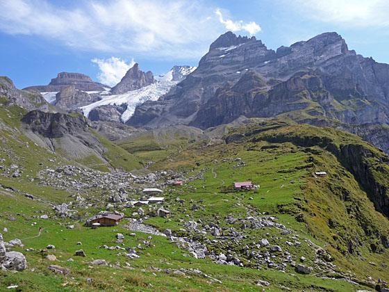
Ober Bergli and the Bluemlisalp glacier
Hikers tackling the steep, strenuous ascent to Hohturli Pass are rewarded with stunning vistas of Oeschinensee Lake, marvelous mountain scenery and close-up views of dramatic glaciers.
See Trail Detail/Full Description
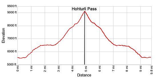
- Distance: 9.8 miles (round trip) to Hohturli Pass
10.4 miles (round trip) to Bluemlisalp Hut and Overlook - Elevation: 5,530-ft. at Trailhead
9,114-ft. at Hohturli Pass
9,350-ft. at Bluemlisalp Hut and Overlook - Elevation Gain: 3,584-ft. to Hohturli Pass
3,820-ft. to Bluemlisalp Hut and Overlook - Difficulty: strenuous
- More Hikes in:
Kandersteg / The Bernese Oberland
Why Hike Hohturli Pass
Many hikers visit Hohturli Pass, the highest pass on the Alpine Pass Route, when walking the challenging trail between Griesalp and Kandersteg. Hikers looking for a slightly easier trail to the pass can opt for this highly scenic out-and-back hike from Kandersteg to Hohturli.
The day starts with a quick gondola ride followed by an ascent and then scenic traverse high above the north side of the Oeschinensee, one of the most beautiful lakes in the Swiss Alps. From the trail enjoy splendid views of the magnificent glacial cirque towering above the lake’s turquoise waters. After walking a little over 2.5 miles the trail reaches the small alp of Ober Bergli, perched at the foot of a hanging valley high above the lake.
From Ober Bergli the trail climbs steeply through rocky meadows, ascends along the crest of an old moraine and then climbs very steep scree-covered slopes to Hohturli Pass (9,114-ft.). The final climb to the pass is up extremely steep wood steps. Along the way the trail enjoys great views of the tongues of the Bluemlisalp Glacier hanging from a ledge along the trail.
From the pass bird's-eye-views extend southwest to the peaks towering above the west side of Kandersteg. Sefinenfurgge Pass, the notch on the saddle between the Hundshorn and Butlasse, is visible to the east. To the north, vistas stretch down the length of the Kiental Valley to Lake Thun and beyond. To the south, dazzling glaciers spill down the flanks of the Bluemlisalp massif.
An optional side trip climbs from the pass to the Bluemlisalp Hut and an overlook beyond the hut with marvelous views of the Bluemlisalp Glacier and massif.
Be aware that this is a steep, strenuous hike gaining over 3,500-ft. in 4.9 miles. In my opinion the scenic rewards more than compensate for the effort. So pick a day that promises good weather, get an early start and enjoy this beautiful hike to Hohturli Pass and the Bluemlisalp Hut.
Elevation Profile
| Support our Site |
Trail Resources
Trail Detail/Full Description / Trail Photo Gallery / Trail Map
Basecamp(s) Information:
Kandersteg
Region Information:
The Bernese Oberland
Other Hiking Regions in:
Switzerland