Dundehorn and Schwarzhorn to the north
This trail is closed due to rockslides
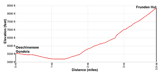
- Distance: 7.8 miles (RT)
- Elevation: 5,226-ft. at Trailhead
Maximum elevation - 8,399-ft. - Elevation Gain: 3,173-ft.
- Difficulty: strenuous
- Basecamp: Kandersteg
- Region: The Bernese Oberland
Trail Description - Frunden Hut
This trail is closed due to rockslides
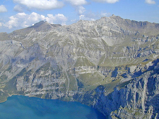
This strenuous hike ascends a very steep, well-constructed trail to Frunden Hut. Excellent views along much of the trail will take your mind off the stiff ascent. Initially the trail features vistas of the Doldenhorn, the Bluemlisalp massif and the Dundenhorn, anchoring the cirque soaring above the Oeschinensee, a gorgeous azure-blue lake. Waterfalls spill down the steep cliffs beneath the peaks, adding to the visual delights.
As the trail gains elevation enjoy ever evolving birds-eye-views of the Oeschinensee and the peaks towering above the north side of this stunning lake. Overhead glaciers tumble down the steep slopes between the Doldenhorn and Bluemlisalphorn while waterfalls cascade down crevasses cut into the cliffs beside the trail.
The hike offers the perfect opportunity to escape the crowds around the Oeschinensee while gaining new perspectives of the impressive mountain scenery. In places fixed cables safeguard sections of the trail that are exposed or may be slippery if wet/icy.
This trail is not recommended for anyone with a fear of heights.
To Frunden Hut
The day starts with a ride up the Oeschinensee Gondola with fine views of the peaks towering above the west side of the Kandersteg valley. (See trailhead directions below.) Upon exiting the gondola station walk east/southeast along a broad track descending on easy grades toward the Oeschinensee. Ahead are lovely views of the high peaks soaring above the lake.
Reach the Schatthaus junction at 0.2 miles and bear right toward Oeschinensee and Frundenhutte. (The trail to the left leads to Hohturli and Bluemlisalphutte.) The path descends through meadows and clusters of trees to the lakeshore and a junction at 0.9 miles. Early in the morning the still waters of the lake reflect the Bluemlisalp massif and its nearby peaks. Photogenic waterfalls spill down the sheer cliffs encircling the lake.
When you are done enjoying the views, return to the junction and turn south on the trail toward Frunden Hut (Frundenhutte). The path travels through meadows above the foot of the lake the then turns left (east), traversing through trees and sections of gravel along the lake's south shore.
At 1.5 miles the path curves away from the lake (southeast) and starts climbing steeply up the slopes beneath the Doldenhorn toward Frunden Hut. Along the way the trail ascends through trees and crosses avalanche chutes. Soon the trees give way to meadows and rock ledges, passing three waterfalls pouring down crevasses etched into the steep cliffs along the trail. Wood bridges cross the streams emanating from the falls.
At 2.5 miles the trail turns south and starts climbing a series of tight, very steep switchbacks straight up a rocky hillside. As you approach a massive rock face the trail curves to the left and zig-zags its way up to a ridge and then continues its stiff climb to the hut. Steps chiseled into the rock and cables secured to the cliff face safeguard this section of the ascent with some exposure.
Reach Frunden Hut (8,399-ft.) at 3.9 miles. Here you efforts are rewarded with superb views of the Frunden Glacier spilling down the north flanks of the Frundenhorn. To the east the Bluemlisalp massif, adorn with glaciers, dominates the views while the Doldenhorn Glacier clings to the slopes beneath its namesake peak.
The overlook, which is 3,200-ft. above the Oeschinensee, features birds-eye-views of the azure blue lake. The Dundenhorn and Bundstock tower above the north side of the lake. Waterfalls tumble down the cliffs beneath Ober Bergli, an alp set atop a grassy knoll.
Roam around the area near the hut to gain different perspectives of the breathtaking scene and to get closer to the Frunden Glacier. There are plenty of great spots to take a break and enjoy the views. After enjoying the scenery walk back to the gondola for a 7.8 miles round-trip hike. Alternatively, instead of taking the gondola to Kandersteg, walk back to town.
To walk back to Kandersteg, return to the junction at the foot of the lake. Here a broad track heads southwest, descending to the village. You can either follow the broad track all the way down or break off from the track and travel along trails for part of the way. The walk back to Kandersteg loses 1,390-ft. and adds 2.4 miles to the day for a 10.2 mile hike.
Elevation Profile
Driving Directions
From the Kandersteg Bahnhof (train station) to the Kandersteg-Oeschinensee Gondola: From the front of the train station, walk south a short distance and then turn left (east) onto Bahnhofstrasse (Train Station Street). Walk about 700-ft. east on Bahnhofstrasse and turn left (north) on Dorfstrasse (the town’s main street). Walk about 650-ft. along Dorfstrasse, passing two streets on the right. Just before the second street you'll go by the Kandersteg Tourism Office on your right, a good place to stop to pickup maps and town information.
A short distance beyond the second street, turn right on a paved walkway heading east through beautiful meadows. The Hotel Bernerhof is directly across from the meadow. Walk a little over 0.3 miles on the pavement to Oschistrasse, passing a pretty little chapel on your right along the way. Turn left on Oschistrasse and walk about 360-ft. to the Kandersteg-Oeschinensee Gondelbahn (gondola). The gondola ride to the top station takes about nine minutes.
See Kandersteg-Oeschinensee Gondelbahn website for the current schedule.
Trail Resources
- Trail Photo Gallery
- Trail Maps
- Basecamp(s) Information: Kandersteg
- Region Information: The Bernese Oberland
- Other Hiking Regions in: Switzerland