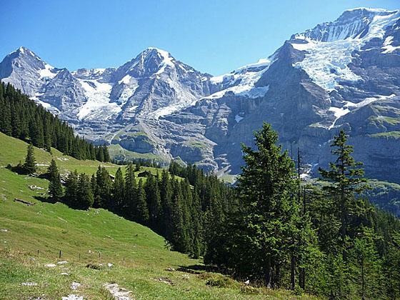
The big three, the Eiger, Monch and Jungfrau, from the overlook
A triad of giants; the Eiger, Monch and Jungfrau, dominate the breathtaking views along this scenic hike from Mannlichen to Wengen.
See Trail Detail/Full Description
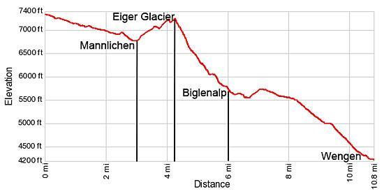
- Distance: 2.8 miles (one way) to Kleine Scheidegg
4.3 miles (one way) to Eiger Glacier Viewpoint
10.8 miles (one way) to Wengen (Complete Hike) - Elevation: 7,293-ft. at Trailhead
6,762-ft. at Kleine Scheidegg
7,250-ft. at Eiger Glacier Viewpoint
4,190-ft. at Wengen (Complete Hike) - Elevation Gain: -531-ft. to Kleine Scheidegg
488-ft. to Eiger Glacier Viewpoint
-3,103-ft. to Wengen (Complete Hike) - Difficulty: moderate
- More Hikes in:
Grindelwald / Lauterbrunnen / The Bernese Oberland
Why Hike Mannlichen to Wengen
Jaw dropping views of the Eiger, Monch and Jungfrau top the list of scenic highlights on this terrific hike between Grindelwald and Wengen. From the top of the gondola at Mannlichen, the route follows a popular trail descending to Klein Scheidegg with panoramic views of the high peaks, including the Wetterhorn, Schreckhorn and the Eiger, towering above the emerald green meadows of Grindelwald.
Beyond Kleine Scheidegg the trail travels to a pretty lake nestled beneath the Eiger’s massive north wall and then climbs to an overlook atop a moraine with magnificent views of the Eiger Glacier spilling down the rugged slopes between the Eiger and the Monch. The trail then turns west, descending a valley through lovely meadows with splendid views of the glacier clad slopes of the Monch and Jungfrau. On warm summer afternoons lucky hikers may see icefalls crashing down the rugged cliffs.
As you descend the valley, views open to the Bietenhorn and Schilthorn towering above the Lauterbrunnen Valley. To the south the Gspaltenhorn, rising above the Sefinental Valley, and the Breithorn, at the head of the Lauterbrunnen valley, dominate the view. At the foot of the valley the trail turns north and descends to Wengen. In Wengen trains head down to Lauterbrunnen and climb to Kleine Scheidegg where connecting trains descend to Grindelwald. A cable car also ascends back to Mannlichen.
Walking from village to village is one of the joys of hiking in Switzerland. This trail is a great option if you wish to walk from Grindelwald to Lauterbrunnen, or vice versa.
Elevation Profile
| Support our Site |
Trail Resources
Trail Detail/Full Description / Trail Photo Gallery / Trail Map
Basecamp(s) Information:
Grindelwald / Lauterbrunnen
Region Information:
The Bernese Oberland
Other Hiking Regions in:
Switzerland