Details: Swamp Canyon 
Distance: 6.0 - 7.6 miles (round trip)
Uncompahgre National Forest, near Telluride in Southwest Colorado
Hike Facts
- Distance: 6.0 - 7.6 miles (round trip)
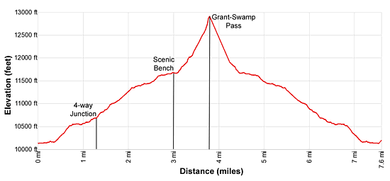
- Elevation: 10,130-ft. - 12,910-ft.
- Elevation Gain: 1,530-ft. - 2,780-ft.
- Difficulty: strenuous
- Trail Highlights: See Trail Intro
- Basecamp(s): Telluride
- Region: Southwest Colorado
Waterfalls, wildflowers and stunning views are the rewards for hikers making the stiff climb up Swamp Canyon to a high bench nestled below Ulysses S. Grant Peak. Extend the hike to Grant-Swamp Pass for breathtaking views of the Ice Lake area.
Trailhead to the Scenic Bench
Distance from Trailhead: 6.0 miles (round trip)
Ending/Highest Elevation: 11,660-ft.
Elevation Gain: 1,530-ft.
Note: Hikers without a high clearance or 4WD vehicle should add 1.2 miles to the round trip distance.
The Swamp Canyon trail starts about 0.6 miles past the Ophir Pass sign on the Ophir Road/Forest Road #630, just to the east of a large avalanche chute channeling a stream. (See driving directions below.) Here a two-track on the right (south) side of the Ophir Road heads southeast. Follow the two-track as it descends the hillside. After walking a little over 0.1 miles bear right to stay on the road. Soon you will hit a flooded section of the two-track. Bypass the water by walking above the left (east) side of the road.
Continue the descent to an area that appears to have been cleared by a bull dozer. Ahead a creek cuts across the remnants of the road. Turn right at the creek and follow the creek downhill to where it hits Howard Creek.
Cross Howard Creek by wading or rock-hopping. On the south side of Howard Creek is a well-defined dirt/gravel road. Ascend the forested road up the south side of the valley, initially on moderate grades. At 0.3 miles the road crosses under electrical lines and soon reaches a green gate with a trail marker.
Beyond the gate the road climbs steeply up three switchbacks (making a left, a right and a left). At 0.7 miles, at the end of the last switchback, the road reaches an intersection. To the right is the continuation of the road, overgrown and blocked by a branch. Straight ahead is a good boot beaten trail. Continue heading east on the boot beaten trail through viewless forest.
At 0.9 miles come to an unmarked junction. Bear right on the trail climbing the hillside. A short distance beyond is a second junction. Again take the right (southeast/south) branch ascending the hillside. Make note of both of these unmarked intersections so that you turn the correct way on the return to the trailhead.
At 1.3 miles reach an unmarked four-way junction. Turn right (southwest) and climb steep switchbacks up timbered slopes. Soon the trail curves to the left (south) and starts ascending on a diagonal along the western slopes of the Swamp Canyon.
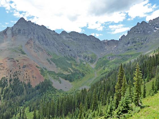
At 1.6 miles the trees begin the thin and the grade moderates a bit. Soon we are passing through intermittent meadows with views of V3 (13,528-ft.), Ulysses S. Grant Peak (13,767-ft.) and Peak 13,309 towering above the head of the valley.
At 1.8 miles we start traveling through a large meadow scattered with small conifers. Below the trail the valley floor of the appropriately named Swamp Canyon is littered with ponds and wet meadows. Ahead are stunning views of the rugged cirque at the head of the valley, anchored by V3 and Ulysses S. Grant massif to the west and South Lookout Peak (13,357-ft.) to the east. Turn around for fine views of Silver Mountain’s multi-hued ridge rimming the north side of the Ophir Valley. Look carefully to see the Blixt Trail, an old mining road, switchbacking up the ridge’s very steep slopes to the left of Chapman Gulch.
At 2.1 miles we temporarily lose the views as the path enters clusters of trees interspersed with small meadows littered with skunk cabbage and wildflowers. A short distance beyond we pass a campsite site amid the trees.
Beyond the campsite the trail emerges from the trees and views open to a small valley along the west side of V3. The path soon crosses a creek and curves to the left (southeast), climbing the talus slopes around the end of a ridge extending north from V3. Beautiful cluster of columbines grow amid the rocks. Great views extend north down the length of the Swamp Canyon Valley to the colorful ridge defining the north side of the Ophir valley. Ahead views open to the lovely high basin at the head of the valley.
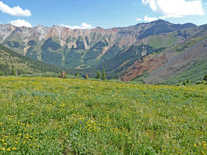
At 2.7 miles the grade abates as the trail reaches the western end of a stunning bench set beneath the south-facing flanks of V3 and Ulysses S. Grant Peak. During early to mid-July the bench is clad in emerald green meadows filled with wildflowers. Three waterfalls cascade down the rugged slopes above the bench. To the north Silver Mountain forms the backdrop for Swamp Canyon. Progress will be slow as you wander through the breathtaking scene.
The easy walk across the bench ends at 3.0 miles where the trail starts climbing toward the upper basin and the Grant-Swamp Pass. For many hikers the meadows are a perfect destination to eat lunch and take in the incredible views before returning to the trailhead.
To Grant-Swamp Pass
Distance from Trailhead: 7.6 miles (round trip)
Ending/Highest Elevation: 12,910-ft.
Elevation Gain: 2,780-ft.
Experienced hikers who are fit, well acclimated and comfortable on very steep, unstable scree slopes many want to continue to the upper basin and the Grant-Swamp Pass. You should not underestimate the difficulty of the next segment that gains over 1,200-ft in 0.8 miles.
From the end of the bench the trail climbs very steep rocky slopes, marked with cairns. After about 0.5 miles the grade eases for a short distance to reach a point below the base of the pass. From here it is an extremely steep scramble up loose talus slopes to the pass. Cairns and a thin trail mark the way.
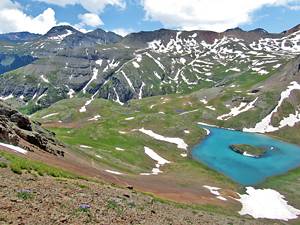
As you crest the pass at 3.8 miles gorgeous views open to the Ice Lakes area and beyond. Island Lake, with its distinctive rock island, lies nestled in the basin beneath the pass. Pilot Knob, Golden Horn, Vermillion Peak and Fuller Peak form the dramatic cirque surrounding the upper Ice Lake Basin. Fuller Lake is seen cradled beneath Fuller Peak. Closer at hand Ulysses S. Grant Peak looms above the pass to the west while South Lookout Peak towers above the pass to the northeast.
When you are done taking in the views, carefully descend from the pass and retrace your steps to the trailhead.
Elevation Profile
| Buy the BookThis opinionated guide includes all the hikes in the Ouray, Telluride, Silverton and Lake City sections of the website plus info on local services and nearby attractions. |
Driving Directions
From Telluride: Drive south from Telluride on Colorado 145 S for 7.3 miles and then turn left (east) onto the Ophir Road (Forest Service Road #630). Continue on the Ophir Road for 2.8 miles. At 2.1 miles you will need to bear right to stay on route and at 2.7 miles turn right to stay on the Ophir Road. A short distance beyond (0.1 miles) is a sign for Ophir Pass and a second sign warning that further travel requires a 4WD.
Typically a high clearance vehicle can make it to the trailhead. 4WD is required if the road is wet. Parties without a high clearance or 4WD should park off the road near the Ophir Pass sign and walk to the trailhead. This will add 1.2 miles to the round-trip distance.
Ascend the rough 4WD for 0.6 miles and find a place to park off the road either before or after the large avalanche chute channeling a creek. There are several pullouts in the area. Just past the avalanche chute (the east side of the chute), look for a two-track road branching right (south/southeast). This road is the starting point for the hike.
Some parties with high clearance 4WD vehicles try to drive a short distance down the two-track. This is not advisable. The road is often flooded and impassable to vehicles.
Trail Resources
Trail Intro / Trail Photo Gallery / Trail Map
Basecamp(s) Information:
Telluride
Region Information:
Southwest Colorado
Other Hiking Regions in:
Colorado