Sneffels Highline 
Distance: 8.0 - 12.7 miles (loop)
Mount Sneffels Wilderness, Uncompahgre National Forest, near Telluride in Southwest Colorado
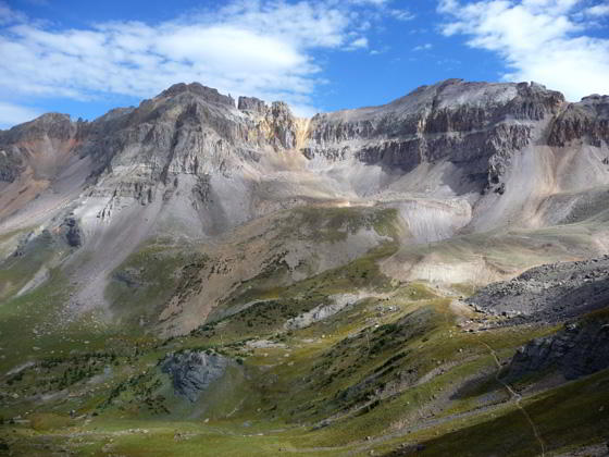
Upper Mill Creek Basin from the saddle
This is my favorite hike in Telluride. The trail crosses a high saddle separating two gorgeous alpine basins, traverses meadows filled with thigh-high wildflowers and serves up spectacular views of the high peaks surrounding the Telluride Valley and the San Miguel Mountains in the Lizard Head Wilderness.
See Trail Detail/Full Description
- Distance: 12.7 miles (loop)
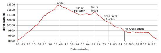
- Elevation: 8,900-ft. at Trailhead
Maximum elevation: 12,280-ft. - Elevation Gain: 3,380-ft.
- Difficulty: strenuous
- More Hikes in:
Telluride / Southwest Colorado
Why Hike Sneffels Highline
If I only had time for one hike in the Telluride area, I’d choose the Sneffels Highline. This classic loop hike, leaving right from town, features spectacular views, two beautiful alpine basins and pretty meadows with thigh-high fields of wildflowers.
Be forewarned the trail is strenuous, covering 12.7 miles and climbing 3,380-ft. to its high point on a saddle below Mt. Emma (12,280-ft.). Don’t let the challenge deter you. Pick a beautiful day and get an early start so you can enjoy this premier hike at a leisurely pace.
Elevation Profile
| Buy the BookThis opinionated guide includes all the hikes in the Ouray, Telluride, Silverton and Lake City sections of the website plus info on local services and nearby attractions. |
Trail Resources
Trail Detail/Full Description / Trail Photo Gallery / Trail Map
Basecamp(s) Information:
Telluride
Region Information:
Southwest Colorado
Other Hiking Regions in:
Colorado