Details: Lewis Lake and Mine 
Distance: 8.0 - 8.8 miles (round trip)
Uncompahgre National Forest, near Telluride in Southwest Colorado
Hike Facts
- Distance: 8.0 - 8.8 miles (round trip)
- Elevation: 10,400-ft. - 12,700-ft.
- Elevation Gain: 2,300-ft.
- Difficulty: moderate-strenuous
- Trail Highlights: See Trail Intro
- Basecamp(s): Telluride
- Region: Southwest Colorado
This scenic hike winds up Bridal Veil Basin past the historic Lewis Mill to Lewis Lake, nestled in a stark glacial basin at 12,700-ft. Along the way pass remnants of the area’s rich mining history, numerous waterfalls and hillsides filled with spectacular wildflowers displays.
Trailhead to Junciton with Blue Lake Trail
Distance from Trailhead: 3.6 miles (round trip)
Ending/Highest Elevation: 11,470-ft.
Elevation Gain: 1,070-ft.
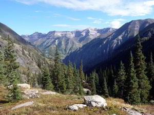
A hiking trip to Bridal Veil Basin starts with a walk or a drive up the 4WD jeep road just past the Pandora Mill at the east end of Telluride. The road features stunning views of Bridal Veil Falls, Telluride and the restored historic power plant atop the falls.
Bridal Veil Falls, the tallest freefalling waterfall in Colorado, plunges 365-ft. from just beneath the power plant to headwaters of the San Miguel River. An excellent viewpoint at the base of the falls is located 1.2 miles up the jeep road at a hairpin curve on one of the switchbacks. The viewpoint is often enveloped in mist from the water thundering over the rock face and hitting a small pool at the base of the falls.
The walk or drive up the remaining 0.8 miles of the road to the trailhead enjoys great views of the steep cliffs forming the head of the Telluride valley and the town in the distance. Along the way dramatic views open to the power plant perched on a ledge just above the falls. The building, restored in the 1990’s, is listed on the National Register of Historic Places.
The power plant, the second oldest AC generation facility in the country, was built in 1907 to supply the Smuggler’s Union Mine. Water driving the generators is piped from Blue Lake (see Blue Lake trail description).
If you plan to walk up the road add 4.0-miles to the round trip hiking distances and get an early start. Walking the road turns this into a 12.8-mile round trip hike to Lewis Lake gaining 3,680-ft. in elevation. For more details on walking the road see the Bridal Veil Falls trail description.
The trail into Bridal Veil Basin starts at a gate blocking vehicle access to the power plant. Duck through the opening in the gate and stay on the seldom used mining road as it swings to the left (south) and enters the basin. In a few minutes pass above the power plant building (on the right). The building and the area around the plant is private property.
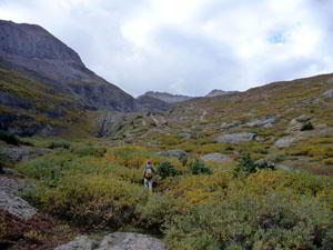
Follow the rocky road as it ascends on moderate grades along the left (east) side of the creek, past picturesque cascades and waterfalls. Switchbacks ease the way up a few steep sections.
During mid-July to early-August the hillsides along the trail are awash in wildflowers. As you climb the trees thin and views open to the north (behind you) to the mountains forming the northern wall of the Telluride Valley.
An unmarked intersection at 11,470-ft. is reached after walking 1.7 miles and gaining 1,072-ft. Continue straight ahead (the road on the right) toward Lewis Lake. The road to the left leads to Blue Lake. (See the Blue Lake description for more information.)
To the Lewis Lake Junction
Distance from Trailhead: 6.2 miles (round trip)
Ending/Highest Elevation: 12,360-ft.
Elevation Gain: 1,960-ft.
Stay on the road as it climbs through meadows and then crosses a stream. Reach an unmarked "Y" intersection at 2.4 miles, a short distance beyond the stream crossing. The road to the right has a pipeline running along the right (west) side of the path. Bear right on the road with the pipeline and continue ascending through pretty meadows, passing a few small tarns along the way. Near the head of the basin two paths are seen in the distance climbing toward the ridge. The path on the left ascends to Columbine Pass above Lewis Lake while the road on the right heads to Ophir.
Reach a third junction at 3.1 miles after walking 1.4 miles and gaining about 900-ft. from the junction with the Blue Lake trail. Turn left to reach the Lewis Mill/Mine and Lewis Lake. (There is no trail sign at the intersection, just a post.) The trail to the right continues toward the head of the basin.
To the Lewis Mill and Mine
Distance from Trailhead: 8.0 miles (round trip)
Ending/Highest Elevation: 12,448-ft.
Elevation Gain: 2,048-ft.
Follow the trail as it heads southeast, traversing a rolling landscape of meadows and rock outcrops on easy grades. Upon reaching a creek (the outlet stream for Lewis Lake) the trail swings south, climbing along the right (west) side of the creek.
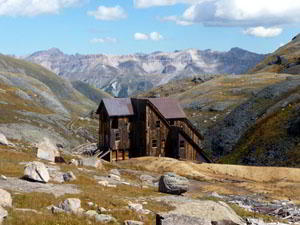
The Lewis Mill (12,448-ft.) is situated about 0.9-miles from the junction on the left (east) side of the trail. A small cabin is located near the Mill and mining debris is scattered around the site.
The 5-story Mill, built in 1907, served as a 60-ton capacity ore-concentration facility in the early 1900’s. Work in 2001 stabilized the structure and a new roof was added in 2006. The building, owned by San Miguel County, is listed the National Register of Historic Places.
To Lewis Lake
Distance from Trailhead: 8.8 miles (round trip)
Ending/Highest Elevation: 12,700-ft.
Elevation Gain: 2,300-ft.
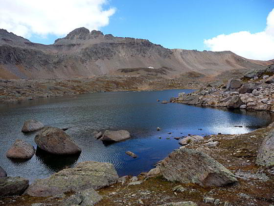
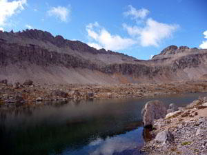
Beyond the Mill the trail climbs a steep rocky drainage gaining 250-ft in 0.4-miles to reach the dam at the end of Lewis Lake (12,700-ft) at 8.8 miles. The lake is set amid a large rocky basin surrounded on three sides with peaks towering above 13,000-ft.
Hikers with the time and energy can follow the very rocky route climbing to Columbine Pass on the ridge to the southeast of the lake. The pass is about 0.5-miles from the lake and entails a climb of 380-ft. From the top of the pass you have a bird’s-eye view of Columbine Lake to the south and the vast panorama of peaks surrounding Telluride.
After taking a break return the way you came, enjoying the wildflowers, waterfalls and scenic views of the mountains rising above Telluride.
Wasatch Trail Junction: The trail up Bridal Veil Basin links to the Wasatch trail in the Bear Creek valley. At the junction with the Lewis Lake and Mine trail stay right (Lewis Lake and Mine are to the left) and follow the trail as it climbs in a southwest direction toward a scree covered hillside. The trail will cross the edge of the scree and ascend toward the head of the basin.
A junction is reached just before the head of the basin. The trail straight ahead leads to Ophir and the Blixt trail. Take the faint trail heading right (west), ascending to an obvious saddle. At the top of the saddle a trail is seen descending into the Bear Creek drainage. This is the Wasatch trail that eventually meets with the Bear Creek trail that descends steeply to Telluride. (This is a VERY long loop and only recommended for experienced hikers!)
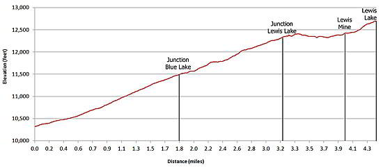
Elevation Profile
| Buy the BookThis opinionated guide includes all the hikes in the Ouray, Telluride, Silverton and Lake City sections of the website plus info on local services and nearby attractions. |
Driving Directions
Driving directions from Telluride: Drive east through Telluride on Colorado Avenue for a little over 2.0 miles past the Pandora Mill to a large unmarked parking area. Park here if you are driving a 2WD vehicle. High clearance AWD / 4WD is recommended beyond this point.
If you are in a high clearance AWD / 4WD follow the dirt road, marked as Forest Road #636 on maps, for 2.0-miles up a series of switchbacks to the Bridal Veil Power plant. The road gets rougher and rockier as you climb.
Parking is VERY limited at the top and fills up early in the morning. Be sure not to block the gate. If there is no available parking, turn around and go back down the road until you find a safe, wide spot to park out of the flow of traffic (and not on private property.) A good place to park is at the base of the waterfall. From the waterfall walk 0.8-miles up the road.
Note: Two-way traffic is permitted between the Pandora Mine and the power plant. The road above the power plant, the notorious Black Bear Road, is one-way downhill toward Telluride. [The Black Bear road, starting south of Red Mountain Pass on Highway 550, goes over Black Bear Pass (12,840-ft.) and descends Ingram Basin on dangerous and difficult switchbacks to meet the 4WD road coming up from Telluride.]
Trail Resources
Trail Intro / Trail Photo Gallery / Trail Map
Basecamp(s) Information:
Telluride
Region Information:
Southwest Colorado
Other Hiking Regions in:
Colorado