Andrews Lake to Snowdon Peak Viewpoint 
Distance: 2.2 miles
Weminuche Wilderness, San Juan National Forest, near Silverton in Southwest Colorado
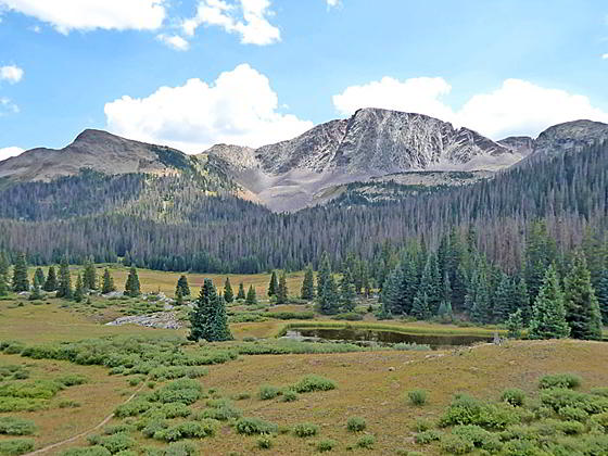
Snowdon Peak from the viewpoint
This short hike ascends the slopes to the south of Andrews Lake, accompanied by fine views of the peaks to the north and west. The hike ends at a viewpoint with beautiful vistas of Snowdon Peak towering above a meadow clad bench with two small ponds.
- Distance: 2.2 miles (RT)
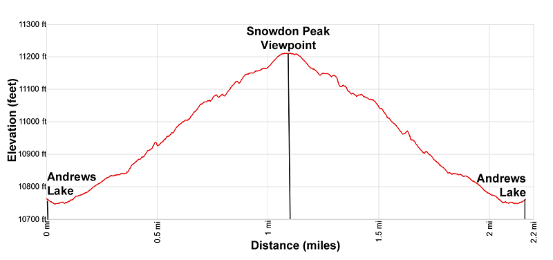
- Elevation: 10,750-ft. at Trailhead
Maximum elevation - 11,210-ft. - Elevation Gain: 460-ft.
- Difficulty: moderate
- Basecamp: Silverton
- Region: Southwest Colorado
Trail Description - Andrews Lake to Snowdon Peak Viewpoint
This is a great hike for families and anyone looking for a short walk while driving the Million Dollar Highway. It is also a good option if the weather precludes hiking in the high country.
The hike to the Snowdon Peak viewpoint starts at pretty Andrews Lake, a popular fishing spot in the Weminuche Wilderness just south of Molas Pass (see driving directions below). From the trailhead at the southwest end of the parking area (near the restroom), follow the broad path heading south, skirting the lake’s western shore. Along the way enjoy fine views of Twin Sisters and Jura Knob rising to the west. Engineering Mountain towers above Engineer Plateau to the southwest. Kendall Mountain, Kendall Peak and Mount Rhoda dominate the view across the lake to the northeast.
At the south end of the lake is a junction. The continuation of the broad track to the left is the trail circling the lake. We bear right (southeast), stepping up off the broad track onto the path heading toward Crater Lake.
The trail now ascends on moderately grades, initially through a small meadow and then up a forested hillside. Switchbacks facilitate the climb. Openings in the trees offer views to the north of West Turkshead and Grand Turk, Storm Peak and the Kendall Mountain area. To the west Jura Knob joins the scene to the south of Twin Sisters.
At 1.0 mile the path reaches a junction with a trail registration box for the Crater Lake Trail. Here the Crater Lake trail continues straight ahead. We bear left on an unmarked trail that leads to a climber’s route to the summit of Snowdon Peak.
Our trail ascends to the crest of a low hill at 1.1 miles where terrific views open to Snowdon Peak and North Snowdon Peak towering above a beautiful meadow with two ponds. Turn right at this point and find a spot to sit along the rock outcroppings atop the ridge crest. This is the Snowdon Peak Viewpoint. Here vistas extend north to the Kendall Mountain area. Behind you are views of Grand Turk and nearby summits.
After enjoying the views simply retrace your steps to the trailhead for a 2.2 mile round-trip hike. During wildflower season I strongly recommend continuing down the Snowdon trail to enjoy the amazing display of wildflowers in the meadows beneath the viewpoint. As you descend to the meadows the trail splits. Early in the season take the trail to the left that stays high and will keep your feet dry. The trail to the right, the lower trail, travels along or near the small creek meandering through the meadow. This area can be quite marshy. The two trails meets at the end of the meadows. Later in the season when the area dries out you can walk out the high trail and then return to the viewpoint via the lower trail near the creek.
Elevation Profile
Driving Directions
Driving directions from Silverton: From the intersection of Main Street in Silverton (State Highway 110) and U.S. 550, drive south on U.S. 550 for 7.3 miles to the Andrews Lake Road. It is 6.4 miles to the top of Molas Pass. The Andrews Lake Road is 0.94 miles beyond the pass. Turn left and drive a little over 0.5 mile on the narrow paved road to the parking area at Andrews Lake. The trailhead is located on the southwest end of the parking area.
Driving Directions from Ouray: Drive south on U.S. 550 for 30.7 miles to the Andrews Lake Road. Andrews Lake Road is 0.94 miles beyond Molas Pass. Turn left and drive a little over 0.5 mile on the narrow paved road to the parking area at Andrews Lake. The trailhead is located on the southwest end of the parking area.
Driving directions from Durango: Drive 45-miles north of Durango on US 550 to the Andrews Lake turn off. The turn off is 6.6 miles beyond Coal Bank Pass and about 0.5 miles from the Lime Creek rest area. Turn right and drive a little over 0.5 mile on the narrow paved road to the parking area at the lake. The trailhead is located on the southwest end of the parking area.
Trail Resources
- Trail Photo Gallery
- Trail Maps
- Basecamp(s) Information: Silverton
- Region Information: Southwest Colorado
- Other Hiking Regions in: Colorado