Richmond Pass 
Distance: 5.6 miles (round trip)
Uncompahgre National Forest, near Ouray in Southwest Colorado
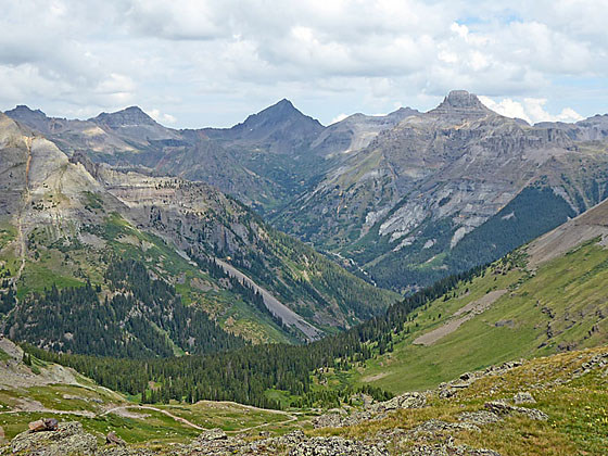
Peaks towering above Yankee Boy Basin
Terrific views of the high peaks towering above the Million Dollar Highway and Yankee Boy Basin are the rewards of this steep climb to a scenic pass to the south of Hayden Mountain.
See Trail Detail/Full Description
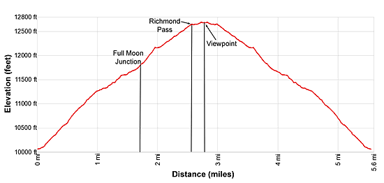
- Distance: 5.6 miles (round trip) to Richmond Pass
- Elevation: 9,910-ft. at Trailhead
12,693-ft. at Richmond Pass - Elevation Gain: 2,783-ft. to Richmond Pass
- Difficulty: strenuous
- More Hikes in:
Ouray / Southwest Colorado
Why Hike Richmond Pass
Fit, acclimated hikers will love this steep trail climbing to Richmond Pass, a scenic saddle on the ridge to the south of Hayden Mountain near Ouray, Colorado. The first section of the hike ascends through beautiful groves of aspen that give way to spruce-pine forest interspersed with small meadows. Across the valley views open to the colorful Red Mountains and the Brown Mountain ridge, anchored by Abrams Mountain to the north. Soon the Twin Sisters and nearby summits to the west of Silverton, Colorado join the scene.
After 1.7 miles the path climbs above the timberline and continues the steep ascent up beautiful tundra-clad slopes. The stunning views now expand to include a sea of peaks to the northeast, including the 14,000-ft. summits in the Uncompahgre Wilderness. Ahead views open to the pass, a saddle on the ridge between Hayden Mountain to the north and Peak 13,011-ft. to the south.
As the trail crests the pass the high peaks towering above Yankee Boy Basin, including Gilpin Peak, Mount Sneffels (14,150-ft.), Cirque Mountain, Teakettle Mountain and Potosi Peak, spring into view. A short walk to an overlook on the west side of the pass yields more great views of the basin along with Chicago Peak and the summits surrounding the Imogene Pass area.
Surefooted hikers can extend the hike by climbing north from the pass to the summit of Hayden Mountain South. With a prearranged car shuttle a longer point-to-point hike descends down the west side of the pass to an old mining road that leads to the Imogene Pass jeep road. The Imogene Pass road is very rugged, requiring a high clearance, 4WD vehicle.
The unmarked trailhead for this hike, located along Highway 550 near the southern end of Ironton Park, is easy to miss. Pay close attention to the driving directions (below). Highway 550 south of Ouray is a narrow, curvy road with spectacular views. It is easy to drive by the unmarked turn while you are admiring the scenery.
Elevation Profile
| Buy the BookThis opinionated guide includes all the hikes in the Ouray, Telluride, Silverton and Lake City sections of the website plus info on local services and nearby attractions. |
Trail Resources
Trail Detail/Full Description / Trail Photo Gallery / Trail Map
Basecamp(s) Information:
Ouray
Region Information:
Southwest Colorado
Other Hiking Regions in:
Colorado