Details: Waterdog Lake 
Distance: 7.8 miles (round trip)
Uncompahgre National Forest, near Lake City in Southwest Colorado
Hike Facts
- Distance: 7.8 miles (round trip)
- Elevation: 8,730-ft. - 11,130-ft.
- Elevation Gain: 2,400-ft.
- Difficulty: strenuous
- Trail Highlights: See Trail Intro
- Basecamp(s): Lake City
- Region: Southwest Colorado
A stiff climb leads to a scenic bench and a pretty lake high above the east side of the Lake City.
Trailhead to Waterdog Lake
This hike might win the award for the least appealing start with the trailhead parking area located adjacent to the Lake City Water Treatment Plant. (See driving directions below.) From the parking area walk up the road past the water treatment facility to the trailhead located on the right (east) side of the road, just before a house.
The trail immediately starts ascending steep switchback through fir forest on private land. Please stay on the trail. Openings in the trees offer birds-eye-views of Lake City. The grade abates briefly as the trail passes beneath power lines at 0.6 miles. The respite is short-lived and soon we resume the stiff climb, now on public land. As you gain elevation Peak 13,092-ft. and its neighbors along the south side of Hanson Creek are seen to the southwest.
At 1.1 miles the trail passes through a large, lovely grove of Aspens. Here we lose the views as the trail continues its relentless ascent.
The grade abates at 1.8 miles as the trail turns left (north/northeast) and enters Horse Park, a beautiful expanse of meadows sprinkled with aspen groves atop a bench. Station Eleven (10,726-ft.), rises to the southwest. Horse Park is part of the Vickers Ranch, so you are back on private property. Please be respectful.
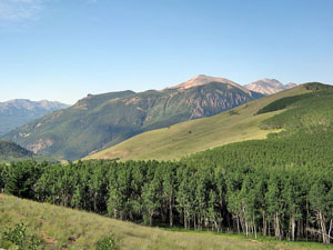
The trail now ascends on easy grades through Aspens and meadows along the western edge of the bench. At 2.4 miles the grade levels as the trail curves to the right (east) and crosses the bench. Views from Horse Park extend southwest to Red Mountain (12,826-ft.), the Redcloud Peak (14,034-ft.) massif, Peak 13,092 and beyond. Crystal Peak rises above the valley to the west.
At 3.0 miles the trail crosses Park Creek and soon reaches a dirt road. Turn left (north/northeast) and follow the road as it climbs on moderate grades through aspen and spruce-fir forest to Waterdogs Lake (11,130-ft.) at 3.9 miles.
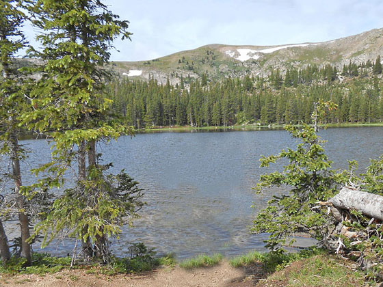
Mesa Seco (12,800-ft.) forms the backdrop for this pretty lake, surround by forest on three sides. A nice afternoon can be spent lazing around the scenic lake, picnicking and fishing. (Check with the Lake City Visitor Center for current fishing conditions before setting out.)
When you are done enjoying the lake, retrace your steps to the trailhead.
Elevation Profile
| Buy the BookThis opinionated guide includes all the hikes in the Ouray, Telluride, Silverton and Lake City sections of the website plus info on local services and nearby attractions. |
Driving Directions
Driving Directions from Lake City: From the intersection of CO-149/Gunnison Ave and 4th Street, head north on Gunnison Ave for 0.5 miles and turn right on 8 and Half Street. This turn is just past Lake City Auto. Cross the bridge and at the next intersection take a left on Water Street and then right on 9th Street. Follow 9th Street for 2 blocks and turn left onto Hotchkiss Street. Head up Hotchkiss Street for 0.1 miles to the parking area on the right (east) side of the road, just before the water treatment facility.
From the parking area walk up the road past the water treatment ponds to the trailhead located on the right (east) side of the road, just before a house.
Trail Resources
Trail Intro / Trail Photo Gallery / Trail Map
Basecamp(s) Information:
Lake City
Region Information:
Southwest Colorado
Other Hiking Regions in:
Colorado