Details: Thomas Lakes 
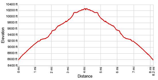
Distance: 8.2 miles (round trip)
Maroon Bells-Snowmass Wilderness, White River National Forest, near Aspen in Central Colorado
Hike Facts
- Distance: 8.2 miles (round trip)
- Elevation: 8,656-ft. - 10,288-ft.
- Elevation Gain: 1,632-ft.
- Difficulty: moderate
- Trail Highlights: See Trail Intro
- Basecamp(s): Aspen
- Region: Central Colorado
This nice hike travels to two pretty lakes cradled beneath the twin-summits of Mt. Sopris. Beyond the lakes the trail climbs steeply to the eastern summit of Mt. Sopris.
Trailhead to Thomas Lakes
Note: This trail is open to mountain bikes up to the Hay Park junction.
The Thomas Lakes/Mt. Sopris trail is located on the south side of the Dinkle Lake Road across from the trailhead parking area. (See driving directions.) Follow the trail as it heads south through a meadow on easy grades. Soon the trail curves to the right (southwest) and ascends an old Jeep road on moderate grades through a forest of oak and aspens. At 0.7 miles the trail switchbacks to the left (east) as it continues its steady climb.
At 1.1 miles the road curves south and soon reaches an open area where views extend over hills, clad in aspen and evergreens, to the high peaks of the Elk Mountains to the east. Beyond this point the grade eases as the road ends at a metal gate. Pass through the metal gate and follow the trail as it travels through low shrubs and Gambel oaks.
At 1.4 miles the trail curves to the left (southeast), ascending through pastures with nice views of the peaks rising to the east and the Roaring Fork Valley to the north. The trail curves to the right (south/southwest) and reaches a “Y” intersection at 1.75 miles. Here the Hay Pass trail branches to the left (south). We turn right (west) toward Mt. Sopris, passing a sign indicating that no bikes are permitted beyond this point.
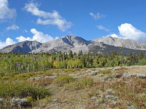
The trail now climbs on moderate grades through pastures. To the southwest the twin summits of the Mount Sopris (12,953-ft.) are now visible above the trees.
At 2.1 miles the trail crests a hill and curves to the left (south) in a large open meadow with stunning views of the Mount Sopris massif to the southwest. After a short, steep climb the path curves right (southwest), ascending on easy grades through groves of aspens and evergreens intersperse with small meadows. The meadows and openings in the trees offer partially obstructed views of Mt. Sopris and the valleys to the north. Along the way the trail gets noticeably rockier.
After crossing a creek at 3.2 miles the trail climbs steeply for a short distance. Soon the grade abates and the trail passes a small pond on the right (west). Another pond lies hidden in the trees to the left (east). Beyond the ponds the trail crosses another small stream.
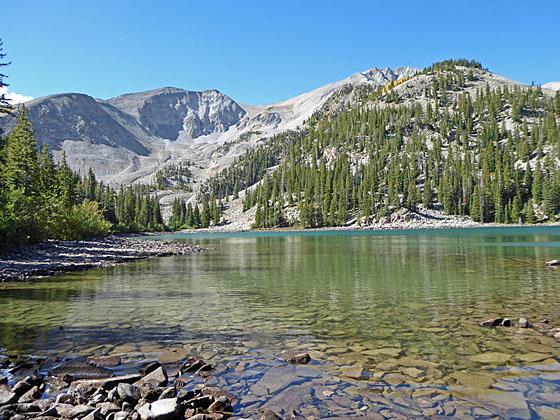
Reach a trail junction at 3.75 miles and the boundary of the Maroon Bells-Snowmass Wilderness. The trail branching left leads to designated campsites. Straight ahead is the main trail towards the upper lake and Mt Sopris. To the right (west), Mt. Sopris towers above the lower (western) Thomas Lake (10,206-ft.).
Take a short detour to the timbered eastern shore of the lower lake. Here views extend across the lake to the steep cliffs and rugged talus slopes along the northeast face of the Mt. Sopris massif. Moraines and rocky slopes, marking the path of ancient glaciers, spill down the slopes of the massif.
To continue to the upper lake, return to the junction and take the broad, rocky trail straight ahead (south) toward the Mt Sopris summit. The trail ascends on easy grades through trees, passing designated campsites along the way. Reach the western shore of the upper (eastern) Thomas Lake (10,284-ft.) at 4.0 miles and the south end of the lake at 4.1 miles. The upper lake is surrounded by trees.
Beyond the upper lake the trail starts its steep climb to the top of Mt. Sopris. With an early start fit, well-conditioned hikers can make the climb in one day. A better option is to camp at one of the designated campsites at the lake and climb the remaining four miles to the summit on the second day. If you backpack into the Thomas Lake please make sure you fill out a free registration form at the trailhead. No camping or fires are only allowed within a quarter miles of the Thomas Lakes except at one of the 12 designated campsites.
Elevation Profile
Buy the BookThis opinionated guide includes all the hikes in the Aspen, Buena Vista, Crested Butte, Marble and Leadville sections of the website plus info on local services and nearby attractions. | |
Driving Directions
Driving Directions from Aspen: From the corner of Mill Street and Main Street in Aspen, drive west on West Main Street/CO 82 W for 25 miles and turn left (south) on Emma Road. In 0.1 miles reach a “T” intersection and turn left (east) to stay on Emma Road. Follow Emma Road as it turns right (south) and become Sopris Creek Road. Drive 1.0 mile to a “T” Intersection and turn right (west) on West Sopris Road. Follow West Sopris Road for 5.6 miles and turn left (south) on Dinkle Lake Road. Drive 2.0 miles on Dinkle Lake Road to the Thomas Lakes trailhead on the left (north) side of the road. The trailhead is across the road on the right (south) side of the Dinkle Lake Road.
Driving Directions from Carbondale: From the intersection of CO 133 and Main Street in Carbondale, travel south on CO 133 S for approximately 1.7 miles and turn left (southeast) on Prince Creek Road (CR 111). Drive 6.3 miles and turn right (south) on Dinkle Lake Road. Drive 2.0 miles on Dinkle Lake Road to the Thomas Lakes trailhead on the left (north) side of the road. The trailhead is across the road on the right (south) side of the Dinkle Lake Road.
Trail Resources
Trail Intro / Trail Photo Gallery / Trail Map
Basecamp(s) Information:
Aspen
Region Information:
Central Colorado
Other Hiking Regions in:
Colorado