Four Pass Loop 
Distance: 26.6 miles (loop)
Maroon Bells-Snowmass Wilderness, White River National Forest, near Aspen in Central Colorado
Introduction
This classic 26.6-mile backpacking circuit around the spectacular Maroon Bells climbs over four 12,000-ft. passes (West Maroon - 12,500 ft.; Frigid Air - 12,415 ft.; Trail Rider - 12,420 ft.; Buckskin - 12,500 ft.) and travels through some of the finest scenery in the Maroon Bells-Snowmass Wilderness. Along the way the popular route through the rugged high peaks of the Elk Mountains traverses gorgeous meadows decorated with wildflowers, visits beautiful alpine lakes and wanders through scenic forest.
Typically it takes three to four days to complete the challenging loop. The trip can be extended with side trips to Geneva Lake and Willow Pass or done at a more leisurely pace to allow time for exploration and relaxation amid the breathtaking scenery.
I recommend walking the loop in a clockwise direction. The trail up the West Maroon Valley is not as steep and therefore easier when carrying a full pack compared to the trail ascending Buckskin Pass. In my view this direction also saves the very best scenery for last. This point can certainly be argued since the entire backpack is really magnificent.
It is best to wait until mid summer to attempt the trip. Early summer trips must contend with swift running rivers swollen with snowmelt and deep snow on the high passes. To avoid the crowds plan your trip for mid-week or in the early fall.
Overnight hikers in the Maroon Bells-Snowmass Wilderness must now use IGBC approved bear proof food storage containers. Starting in 2023 backpackers will be required to make advanced reservations for designated camping areas. Permits must be purchased in advance at recreation.gov. For more information on the new food storage and permit rules along with other regulations covering overnight trips in the wilderness see the Maroon Bells-Snowmass Wilderness Regulations at the bottom of the trail details (description) page.
Trailhead to West Maroon Pass
Distance: 6.5 miles (one-way) to West Maroon Pass (12,500-ft.)
Elevation gain/loss: 2,920-ft.
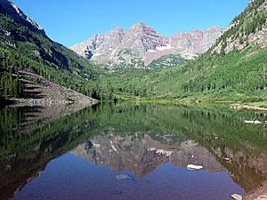
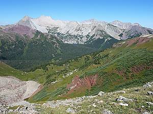
Few trails can surpass the stunning views from the start of the Four Pass Loop at the foot of Maroon Lake. Mirrored in the lake’s waters are the iconic Maroon Bells (14,156-ft. and 14,014-ft.), towering above the head of the valley. Pyramid Peak’s (14,018-ft.) jagged crags rise to the south while the crimson spires of the Sievers Mountains form the backdrop for beautiful aspen groves to the north.
Follow the Maroon-Snowmass trail along Maroon Lake’s north (right) shore to a junction at the "Deadly Bell's Kiosk" near the head of the lake. Progress will be slow along this section of the trail as the gorgeous scenery invites frequent stops.
At the junction the Scenic Loop Trail branches left. We turn right to stay on the Maroon-Snowmass trail, which ascends a wide rocky path through Aspen and spruce trees along the northwest side of the valley. Openings in the trees offer views of rugged Pyramid Peak rising to the south.
About a mile from the start the moderately steep trail climbs an ancient rock slide forming a natural dam that created Crater Lake. As you reach the top of the slide enjoy wonderful views of the Maroon Bells and the Sleeping Sexton, located on the ridge extending north from North Maroon Peak. From the top of the slide the trail descends gently to Crater Lake.
Slightly before reaching Crater Lake arrive at a junction at 1.7 miles. Continue straight ahead (south) on the West Maroon trail toward Crater Lake and West Maroon Pass. The Maroon-Snowmass trail to the right (west) leads to Buckskin Pass.
After descending to the foot of Crater Lake the trail traverses the lake’s right (western) shoreline. Along the way enjoy wonderful views of the Maroon Bells. (Backpackers will find designated campsites among the trees on the western side of the lake.)
At the head of the lake vistas open up the valley. Watch for waterfalls cascading down the western valley wall along this section of the trail.
The trail now follows a gentle grade through meadows, willow thickets and trees and then climbs steeply over a rockslide spilling from the eastern flanks of Maroon Peak. Be sure to turn around at the top of the slide and enjoy great views down valley.
Beyond the slide the trail negotiates a narrow corridor between the creek and talus fields, passing through willows tickets and conifer stands. As the corridor constricts, the trail crosses a few talus fields before being forced to cross to the east side of West Maroon Creek at 3.6 miles. Early in the season you will need to wade the creek. As the snow runoff subsides, you should be able to rock hop across the braided channel without getting your feet wet.
On the east side of the creek the ascent steepens as the path bashes its way through a large thicket of willows and then continues climbing through a landscape of scrub growth interspersed with conifer stands, some of which harbor nice campsites. Depending on the time of year you might see waterfalls spilling down the eastern wall of the valley along this segment of the trail.
At 4.5-miles the trail crosses back to the western side of the creek and continues its ascent. Soon the last of the trees give way to meadows interspersed with thickets of scrub willows. The grade now steepens as you approach the head of the valley, a large basin rimmed with maroon cliffs and clad in emerald green meadows sprinkled with wildflowers. Be sure to turn around as you climb and take in the wonderful views of the Pyramid massif towering above the eastern side of the valley.
The trail through the basin’s meadows veers right (west) as it negotiates the rolling landscape. Near the head of the basin the path crests a rise and heads southwest toward a low point on the ridge. As you near the ridge the way to the pass becomes apparent. The final slog through meadows on the stiff ascent to the pass gains 800-ft. in 0.7 miles.
From the top of the pass views extend west to Treasure Mountain. Below are the vast meadows of Purity Basin. To the northeast the Maroon Bells and Pyramid massifs fill the skyline. Belleview Mountain rises along the rugged ridge extending northwest from the pass.
Note that beyond the designated camping sites a Crater Lake, camping came be found in the conifer stands along the West Maroon Valley. It is best to camp before West Maroon Pass or after Frigid Air Pass. Camping spots are very difficult to find between the two passes.
West Maroon Pass to Trail Rider Pass
West Maroon Pass (12,500-ft.) to Frigid Air (12,400-ft.)
Distance: 2.4 miles (one way)
Elevation gain/loss: +687-ft./-787-ft.
Frigid Air (12,400-ft.) to Trail Rider Pass (12,420-ft.)
Distance: 7.1 miles (one way)
Elevation gain/loss: +2,150-ft. / -2,130-ft.
From the top of West Maroon Pass the trail descend steeply on switchbacks through scree covered slopes and meadows to Purity Basin, renowned for its amazing displays of wildflowers. After descending 0.75 miles from the pass and losing 800-ft the trail reaches the junction of the Frigid Air Pass Trail, heading right. The trail to the left leads down the East Fork valley to Schofield Park.
Turn right toward Frigid Air Pass, following the undulating trails as it ascends northwest through lovely meadows. To the west/southwest are gorgeous views of Galena Mountain, Treasure Mountain, Mount Baldy, Cinnamon Mountain and, in the distance, Purple Mountain and the other peaks of the Ruby Range. Peak 12648, a red pyramid-shaped mountain, towers above the valley to the northwest.
Reach a junction near a small pond beneath Peak 12648. Turn right (north) on the signed trail to Frigid Air Pass. The trail to the pass skirts the left (west) side of the pond and climbs very steep switchbacks to Frigid Air Pass (12,415-ft.), gaining 365-ft in 0.3 miles.
As you crest the pass stunning views open to the Maroon Bells towering above the emerald green meadows of Fravert Basin. The white granite of Snowmass Mountain (14,092-ft.) and Hagerman Peak (13,841-ft.), dominating the view to the northwest, stand in sharp contrast to the crimson-brown mudstone of the Maroon Bells massif. Bellview Mountain (13,233-ft.) rises along the ridge at the head of Fravert Basin. Behind you, to the west/southwest, Mt Baldy, Treasure Mountain and Purple Mountain fill the skyline.
Descend from the pass via a series of steep switchback into the Fravert Basin, passing through meadows sprinkled with wildflowers and alpine scrub. This section of the trail provides lovely views of the Maroon Bells as well as the red rock ridges lining the north and eastern sides of the basin.
As you lose altitude the grade abates a bit. About 1.3 miles from the pass the trail travels through a spruce forest and then skirts the edge of the woods, paralleling the course of the North Fork of the Crystal River, which is really just a stream at this point. Along the way you will pass a few campsites.
At 2.75 miles from Frigid Air Pass the trail enters the woods and then drops down a steep headwall to the lower basin alongside cascades and small waterfalls on the North Fork. As the descent steepens, the river becomes a magnificent waterfall spilling down a rocky gorge gouged out of the headwall. At the base of the headwall the path enters a large meadow that affords wonderful views of the falls and a nice campsite sheltered in a copse of trees.
Beyond the meadow follow the trail through spruce forest and meadows to a crossing of the North Fork of the Crystal River. Just before the crossing reach a trail junction. The path heading left leads to a camping area. Stay right and cross to the river. (Signs in the area point toward Lead King Basin.)
On the other side of the river the trail passes through meadows and a few stands of spruce trees, staying above the marshy valley floor. Just under 0.9 miles from the river crossing reach a second junction signed for Geneva Lake, heading left, and Trail Rider Pass, to the right. Turn right and climb a series of steep switchbacks ascending through meadows and aspen groves. Great views of the Maroon Bells to the southeast and Lead King Basin to the west help divert your attention from the stiff climb.
When the trail reaches a deep drainage it turns north and continues to switchback uphill beside the creek to second junction with a trail leading to Geneva Lake. This section of the trail, from the first junction with the Geneva Lake trail to the second junction, gains 1,130-ft in a mile.
At the second trail junction the path to the left (west) crosses the creek and heads to Geneva Lake. Our trail turns right (northeast) and continues ascending the drainage, crossing the creek twice before turning right (east) and climbing steeply to the top of a ridge with the help of a few switchbacks.
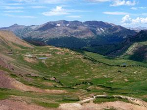
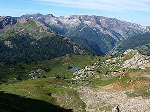
From the top of the broad ridge views to the southwest extend to the Treasure Mountain massif and the peaks around Lead King Basin. To the north Snowmass and Hagerman Peaks rise above the beautiful basin beneath Trail Rider Pass, the saddle on the ridge at the head of the basin.
Follow the trail as it drops gently into the basin, passes to the right of a small lake and then wanders northeast through beautiful meadows. Rock outcroppings and small clusters of trees scattered about the basin harbor great, albeit exposed, campsites.
The trail arcs left (north) near the head of the basin and climbs through flower-speckled meadows toward the pass. The expansive panorama to the southwest along with the ever improving views of Hagerman and Snowmass Peaks serve as distractions from the steep climb to the pass that gains 700-ft. in 0.6 miles.
As you crest the pass views unfold to Snowmass Lake, cradled in a granite cirque to the northeast. The jagged crags of Snowmass and Hagerman Peaks rise along the ridge extending northwest of the pass. Treasure Mountain dominates the skyline to the southwest.
Trail Rider Pass to Buckskin Pass
Trail Rider Pass (12,420-ft.) to Snowmass Lake (10,980-ft.)
Distance: 2.2 miles (one way)
Elevation gain/loss: -1,440-ft.
Snowmass Lake (10,980-ft.) to Buckskin Pass (12,462-ft.)
Distance: 3.8 miles (one-way)
Elevation gain/loss: +1,692-ft./-210-ft.
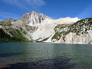
On the eastern side of Trail Rider pass the trail descends on switchbacks through alpine meadows and then follows a descending traverse along a steep hillside high above the southeast side of Snowmass Lake. The grade steepens as the rocky trail skirts a talus field. Past the talus field the path crosses a large meadow and then enters the trees. After losing 1,400-ft. in just under 2.0 miles from the pass the trail reaches a signed junction with a path heading left to Snowmass Lake. The short spur trail to Snowmass Lake leads to a large camping area at the southeast end of the lake.
The views from the vantage points at the end of the Snowmass Lake are sublime. Massive Snowmass Mountain (14,092-ft.) towers above the head of the lake. Hagerman and Snowmass Peaks rise along the ridge extending south from Snowmass Mountain while a jagged line of granite peaks rims the northwestern side of the lake.
To continue on the Four Pass Loop return to the signed junction with Snowmass Lake. Take the path pointing in the direction of the Maroon-Snowmass Trail (essentially straight ahead), cross a small stream and come to a second junction in 0.1-miles with the Maroon-Snowmass Trail. Here a sign points right (southeast) toward Buckskin Pass. Turn right and follow the trail as it ascends gentle grades through forest to cross a minor ridge and then drops down to a large marshy meadow. The trail skirts the north side of the meadow and crosses Snowmass Creek on two logs. Views from the meadows extend southeast up the Lost Remuda Basin to the west face of the Maroon Bells.
At the end of the meadows, about 1.4 miles from the junction with Snowmass Lake, the trail starts climbing steep switchbacks up a wooded ridge, gaining over 700-ft in 0.9 miles. At the top of the ridge trees give way to meadows and the grade abates as the path crosses two small streams. Good campsites can be found in the area around the stream crossing. Ahead Buckskin Pass is clearly visible on the ridge to the left of the rocky crag.
Beyond the stream crossing the trail ascends steeply through alpine meadows to Buckskin Pass, gaining 900-ft. in 1.2 miles. As you crest the pass a stunning panorama springs into view. To the east Pyramid Peak (14,018) and its jagged ridgeline of 13,000-ft. peaks dominate the skyline. The iconic Maroon Bells anchor the rugged ridge to the southeast of the pass. To the west Snowmass Peak, Hagerman Peak and Snowmass Mountain (14,092-ft.) tower above Snowmass Lake. Rugged Capitol Peak (14,130-ft.) and Mount Daly rises along the ridge extending northwest from Snowmass Mountain.
Buckskin Pass to the Trailhead
Distance: 4.6 miles (one-way) to Trailhead (9,580-ft.)
Elevation gain/loss: -2,882-ft.
Descend the east side of Buckskin pass on steep switchbacks through meadows sprinkled with wildflowers. Along the way enjoy wonderful views of North Maroon Peak, the Sleeping Sexton and Pyramid Peak. The initial descent to the junction with the trail to Willow Pass loses over 700-ft. in 0.7 miles. At the junction continue following the switchbacks downhill to the right. The trail ascending to the left leads to Willow Pass.
At the foot of the basin the trail descends a steep gully beside a small stream festoon with wildflowers and enters Minnehaha Gulch. Initially the trail stays on the right (west side) of the gulch as it drops through hillsides clad in pretty meadows and down trees, toppled by avalanche activity. About 1.5 miles from the pass the trail crosses the east side of the stream and continues its descent through trees and meadows. Good campsites are scattered throughout Minnehaha Gulch.
At 2.3 miles from the pass the path swings northeast away from the gulch and descends steeply through aspen and spruce forest to a trail junction just beyond the north end of Crater Lake, 1.7 miles from the trailhead. Backpackers looking for a nice place for a break might want to take a short detour to visit the pretty lake nestled beneath the photogenic Maroon Bells.
After admiring Crater Lake return to the junction and head left, ascending an ancient rockslide that forms a natural dam holding Crater Lake. As you reach the top of the slide be sure to turn around and enjoy wonderful vistas of the Maroon Bells and the Sleeping Sexton.
Descend from the rockslide on a moderately steep grade. At the foot of the slide, about 1.0 mile from the Maroon Lake trailhead, the rocky trail widens and continues its descent along the northwest side of the valley to a trail junction near the head of Maroon Lake. At the junction follow the trail traversing along the lake’s north shore to the trailhead, along the way enjoying the stunning views of the Maroon Bells, Pyramid Peak and the Sievers Mountains.
Maroon Bells-Snowmass Wilderness Regulations
Before leaving on your backpack, please check the White River Forest website Wilderness Regulations page for current regulations to insure that there are not any temporary closures or other restrictions not listed below.
Food Storage -- NEW!!!:
a) Bear proof food storage is now required in the Maroon Bells-Snowmass Wilderness. All food, garbage and attractant must be stored in hard-sided bear-resistant containers. The Maroon Bells-Snowmass Wildereness is in bear country and due to an increase in use, increase in bear activity and a focus on safety the Forest Service has instituted new regulations that requires overnight hikers to use IGBC (Interagency Grizzly Bear Committee Courtesy) approved bear proof food storage containers. Approved bear cannisters can now be rented or purchased in Aspen at Aspen Expeditions and Ute Mountaineering. Many outdoor stores sell the containers. If you intend to rent a container, check ahead of time to determine availability.
b) As a reminder of proper use of the containers; all food (including alcohol), trash, and toiletries must fit in the container.
Permits:
NEW - Backpackers Need Advanced Reservations for Designated Camping Areas: Advance reservation overnight permits are required for the busiest areas of the Four Pass Loop in the Maroon Bells-Snowmass Wilderness (including Snowmass Lake and Geneva Lake). Permits must be purchased in advance at recreation.gov. The designated camping zones are: the Crater Lake Zone, the Maroon Zone (from Backskin Pass to West Maroon Pass except for the area designated by the Crater Lake Zone), the East Fork Zone (from West Maroon Pass to Frigid Air Pass), the Snowmass Lake Zone (from Frigid Air Pass to east of Snowmass Lake) and the Upper Snowmass Zone (from east of Snowmass Lake to Buckskin Pass). Note: Backpackers deviating from the standard Four Pass Loop hike should be aware that there are also zones around Geneva Lake and Capitol Lake.
For overnight trips outside of the permit zones, free self-registration is required. Self-registration permits are available at trailheads, parking lots, and/or wilderness boundaries – visitors must carry a copy of the registration with them during their visit.
Camping:
a) Is not allowed within one hundred (100) feet of any lake, stream or National Forest System Trail;
b) Is not allowed within 1/4 mile of Conundrum Hot Springs, Copper Lake, Crater Lake, Geneva Lake, Capitol Lake, and Thomas Lakes, except at designated campsites.
Campfires:
a) Are not allowed within one hundred (100) feet of any lake, stream or National Forest System Trail;
b) Are not allowed within ¼ mile of Crater Lake;
c) Are not allowed above 10,800 ft. elevation
Group Size: No more than 10 persons per group, and a maximum of 15 pack or saddle animals. Note: see current regulations regarding hitching, hobbling, tethering and livestock feed for pack animals on the White River National Forest Wilderness Regulations page (url: http://www.fs.usda.gov/detail/whiteriver/specialplaces/?cid=stelprd3825863 ).
Dogs:
a) All dog must be under physical restraint of a leash not to exceed six (6) feet in length.
b) Dogs are not allowed within the Conundrum Creek Valley from Silver Dollar Pond (2.25 miles North of Conundrum Hot Springs) to Triangle Pass (1.5 miles Southwest of Conundrum Hot Springs), including Conundrum Hot Springs.
Switchbacks: Please don’t cut switchbacks. "Short-cutting" switchbacks causes soil erosion! When you cut a trail you kill vegetation and loosen soil creating a new trail that channels water from storms and snowmelt, causing erosion and trail damage.
Leave No Trace: Always practice Leave No Trace principles when backpacking.
Hike Facts
- Distance: 26.6 miles (loop)
- Elevation: 9,580-ft. - 12,500-ft.
- Elevation Gain: 2,920-ft.
- Difficulty: strenuous
- Basecamp(s): Aspen / Crested Butte
- Region: Central Colorado
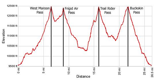
Elevation Profile
Driving Directions
Driving Directions from Aspen:
From Aspen: The Maroon Bells has limited accessibility by car. From June 9th through October 8th the Maroon Creek Road is restricted to vehicles from 8:00 a.m. to 5:00 p.m. beyond the T-Lazy 7 Ranch, unless you have campground reservations or you are overnight backpacking.
A shuttle bus, which leaves every 20 minutes, departs from the Aspen Highlands ski area. There is paid parking at Aspen Highlands or you can take the free Castle Maroon Bus from the Rubey Park Transit Center in downtown Aspen to Aspen Highlands. Dogs are allowed on the bus. Bus tickets that cover the bus and admission to the Maroon Bells Scenic area are sold at Four-Mountain Sports in Aspen Highlands. Check the White River National Forest website for the latest information before setting out on your trip.
Please note the Maroon Bells Scenic Area is a recreation fee area. The Interagency, Senior & Golden Access Passes are honored. Fees apply at all times. Self pay stations are available during off hours.
If you are driving to the Maroon Bells Scenic Area or Aspen Highlands for the shuttle bus from downtown Aspen, follow Hwy 82 heading west to the roundabout just outside of town. Exit the roundabout at the Maroon Creek Road. In approximately one mile reach Aspen Highlands, turn left here for the shuttle.
If arriving during non-bus hours or heading to the backpacker's overnight parking area, continue another 4 miles to the Maroon Bells Scenic Area Welcome Station. The use fee will be collected here, or in the fee tube immediately behind the station if unmanned. Continue another 5 miles to the parking lot at Maroon Lake. Parking is VERY limited in both the day use and overnight lots.
From Crested Butte: The Four Pass Loop can also be started from the East Fork trailhead near Schofield Park. Follow the trail to the Frigid Air/West Maroon junction and then start the loop from there. (The one-way distance to the junction is 3.1 miles.)
From the intersection of Elk Avenue (main street) and 6th Street in Crested Butte, head north on 6th Street, which turns into the Gothic Road (sometimes referred to as the Schofield Pass Road). Follow the Gothic Road (CO 317) for 13.2 miles to Schofield Pass, passing the ski area and the research facilities at Gothic along the way. The dirt road is suitable for 2WD cars up to the town of Gothic at 7.9 miles. Beyond Gothic the road become rougher and a high clearance/4WD vehicle is required.
Continue over Schofield pass, descending the north side of the pass on switchbacks and then through meadows for 0.8 miles and turn right (east) into the signed East Fork trailhead. The turn is right before you hit Schofield Park, a large open park at the foot of the switchbacks. As you enter the trailhead, bear right into the parking area. The road branching to the left is for horse trailers.
Trail Resources
- Trail Photo Gallery
- Trail Maps
- Basecamp(s) Information: Aspen / Crested Butte
- Region Information: Central Colorado
- Other Hiking Regions in: Colorado