Brins Mesa – Soldier Pass Loop 
Distance: 5.1 - 6.6 miles
Red Rock Secret Mountain Wilderness, Coconino National Forest, near Sedona in Arizona's Red Rock Country
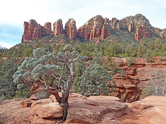
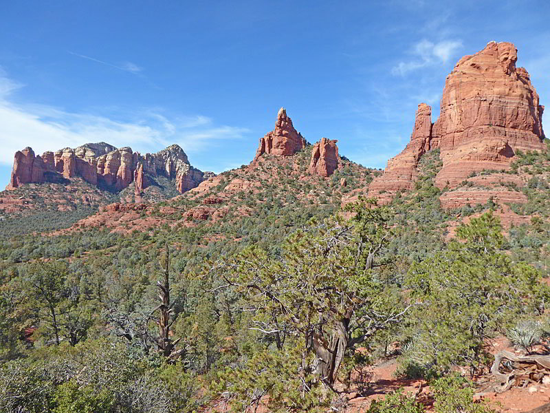
View from the area around the Seven Sacred Pools
This great loop features terrific views of the red rock formations towering above Mormon Canyon, Soldier Pass and the upper Dry Creek Valley and visits some popular Sedona destinations including the Seven Sacred Pools, Devil’s Kitchen and the Soldier Pass Cave.
- Distance: 5.1 - 6.6 miles (Loop)
- Elevation: 4,530-ft. at Trailhead
Maximum elevation - 5,450-ft. - Elevation Gain: 920-ft.
- Difficulty: moderate
- Basecamp: Sedona
- Region: Arizona's Red Rock Country
Trail Description - Brins Mesa – Soldier Pass Loop
Why Hike:
Views both near and far are the highlights of this terrific loop hike incorporating four trails, Brins Mesa, Soldier Pass, Jordan and Cibola. Along the way the loop passes scenic viewpoints and visits the Seven Sacred Pools and Devil’s Kitchen, popular Sedona landmarks. Optional side trips visit the Brins Mesa Overlook and the Soldier Pass Cave.
The loop can be started from either the Jordan/Jim Thompson trailhead of the Soldier Pass Trailhead. The Soldier Pass parking lot, open from 8 a.m. to 6 p.m., only has space for 14 cars. The Jordan/Jim Thompson trailhead is the better choice. The lot is much larger and is always open. That being said, it is a good idea to get an early start since even this parking lot fills early.
Sections of this trail, particularly the lower end of Soldier Pass Canyon, are very popular. Attractions like the Seven Sacred Pools and Soldier Cave get crowded since they are also accessible via a Jeep Road.
Trail Detail
The Brins Mesa – Soldier Pass Loop is composed of four trails; Brins Mesa, Soldier Pass, Jordan and Cibola. The loop can be started at the Jordan Trailhead (Brins Mesa/Jordan/Cibola trails) or the Soldier Pass trailhead (Soldier Pass/Jordan trails). I recommend walking the loop in a counter-clockwise direction, starting at Jordan Trailhead and walking up Brins Mesa. With an early start you will get the climb to Brins Mesa done during the cool of the morning.
Others, whose primary objective is to visit Soldier Pass Cave, suggest walking clockwise so that you get to the cave early in the day before it gets crowded. The Jordan Pass lot is also the best option for walking the trail in the clockwise direction. See the driving directions (below) and the description of the Soldier Pass Trail for more information.
This description hikes the Brins Mesa – Soldier Pass Loop in the counter-clockwise direction, starting at the Jordan trailhead, (also known as the Jim Thompson trailhead). The trail begins near a kiosk along the west side of the parking area. Before setting off enjoy the great views of the Fin, the Acropolis and Tisha Spire rising above the east side of Mormon Canyon.
A short walk west along the path quickly leads to a trail junction. Turn right on the signed Brins Mesa Trail (#119). The trail, an old jeep road, climbs over a low rise and then ascends on easy grades through junipers, pinyons and cypress trees along the west side of Mormon Canyon. Views encompass the Cibola Mitten and Brins Butte to the west. The Fin and the rugged formation along the west facing slopes of Wilson Mountain dominate the view to the east/northeast.
After crossing a shallow drainage the trail reaches the base of the southern slopes of Brins Mesa at 1.0 mile. The path now climbs steeply up a series of red rock “stairs,” gaining almost 400-ft. Along the way enjoy ever improving views of the formation towering above Mormon Canyon.
A beautiful panorama springs into view as the trail crests Brins Mesa and quickly reaches a junction at 1.4 miles. Rugged formations rise above the mesa to the west while Wilson Mountain and Lost Wilson Mountain dominate the view to the north/northeast. Straight ahead are distant views of the multi-hued formations towering above the upper Dry Creek Valley. To the east the rugged walls rimming Mormon Canyon command our attention.
Side Trip to Brins Mesa Overlook
At the junction, the unmarked trail to Brins Mesa Overlook branches right (east/northeast). If time and energy permit, I highly recommend this scenic side trip.
After turning right toward the Overlook, follow the boot beaten path as it ascends on easy grade through grasses, brush and scattered junipers. (The top of the mesa is still recovering from a June 2006 wildfire.)
At 1.7 miles reach a “Y” intersection. The short spur trail to the right leads to an overlook above the south rim of the mesa with fine views south to Table Top Mountain, Twin Buttes, Lee Mountain and Munds Mountain. This is an optional turnaround point for parties that do not want to climb all the way to the overlook.
Beyond the viewpoint the trail ascends on easy to moderate grades along the southeast side of the mesa accompanied by fine views of Wilson Mountain and the formation rimming the east side of Mormon Canyon. Soon views open straight ahead to an overlook situated atop a red rock knoll.
At 2.1 miles start the final ascent up to the overlook, which requires minor amount of scrambling to reach the top the knoll at 2.15 miles. The overlook enjoys panoramic views stretching from Capitol Butte, rising above Soldier Mesa to the southwest, to the multihued formation towering above upper Dry Creek Valley to the northwest. To the south views stretch down the length of Mormon Canyon to Twin Buttes and Bell Rock. During the early spring or after it rains you may be lucky enough to see Angel Falls plunging down a pour-off along the western slopes of Wilson Mountain.
When you are done enjoying the views, retrace your steps to the junction at 2.9 miles and then turn right (northwest) on the continuation of the Brins Mesa Trail.
To the Soldier Pass Trail
Note: The mileage for the rest of this hike assumes you visited the overlook. If you skip the overlook subtract 1.5 miles from the mileage.
The Brins Mesa Trail now heads northeast descending gently across the mesa through grass and brush. Great views encompass the formations rising to the west/southwest including Cathedral Butte and Coffee Pot Rock. Ahead are fine vistas of Maroon Mountain and the colorful formations rimming the upper Dry Creek Valley. Lost Wilson and Wilson Mountains fill the skyline to the north/northeast. Over the course of the descent the vegetation thickens and soon trees start to appear.
At 3.5 miles the trail curves to the left (west) and reaches the junction with the Soldier Pass Trail. To the right is the continuation of the Brins Mesa trail dropping down to Forest Road 152. We bear left on the Soldier Pass trail.
The path climbs over a low ridge accompanied by beautiful views of the upper Dry Creek Valley to the north/northeast and then curves to the left (south), descending to Soldier Pass at the head of Soldier Pass Canyon at 3.8 miles. Here great views open to Brins Butte, the Cibola Mitten and the Sphinx rising above the east side of the canyon. Peak 5977 and Coffee Pot Rock tower above the canyon to the west.
The trail now descends on moderate to moderately steep grades into the canyon, traveling through junipers and brush. Multi-hued walls with distinctive formations rim the canyon to the west. At 3.9 miles views open to Soldier Pass Arches and Cave carved out of the red rock walls along the east side of the canyon.
At 4.25 miles pass a sign marking the boundary for the Red Rock – Secret Mountain Wilderness. Past the sign look for an unmarked trail branching left (northeast). This is the trail to the Soldier Pass Arches and Caves. (There is a brown and white “National Forest Wilderness” sign nailed to a tress along the right side of the spur trail.)
Solider Pass Arch and Cave
(Note: The mileage to the cave is not included in the mileage for the loop.)
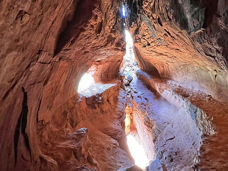
The Soldier Pass Cave is a very popular site in Sedona. Don’t expect solitude. The trail to the arches and cave is steep and rocky. The final ascent into the cave requires scrambling up a steep, rocky slope that is much easier to get up than down. (Many people will not be comfortable climbing into the cave.)
To visit the arches and cave turn left at the unmarked junction and follow the boot beaten path through trees, bushes and cacti. Soon you will reach an open expanse of slickrock. Stay to your left as you ascend the slickrock to find the continuation of the dirt path that now climbs very steeply up a rocky trail with some exposure. Reach the base of the cliff after 0.35 miles from the junction. Here there are three arches. The entrance to the cave that everyone wants to photograph is on the right.
To visit the interior of the cave you need to climb/scramble up a very steep, rock slope. (Don’t be surprised to find a line of people waiting to enter the cave.) Openings in the cliff face light the red rock interior of the cave, creating opportunities for stunning photos.
The arches offer shady places to get sit with beautiful views of Capitol Butte and Peak 5977 to the east. When you are done visiting the site, descend carefully to the trail junction and turn left to continue down the Solider Pass Trail. Total round trip distance for this side trip is 0.7 miles.
Finishing the Loop
Note: The mileage for the side trip to the Cave and Arches is not included in the trail mileage. Add 0.7 miles to the mileage below to include the side trip.
Beyond the junction the grade abates and the trail soon reaches a signed junction at 4.4 miles. Bear left here, in the direction indicated by the sign, to stay on the Soldiers Pass trail. To the right is a path to a Jeep Road.
The undulating path ascends on easy grades to a high point at 4.5 miles with fine views of Peak 5977 and Coffee Pot Rock rising to the southwest. The trail now continues is undulating descent to the Seven Sacred Pools at 4.9 miles. This series of small pot holes hold water even during dry periods. Peak 5977 and Coffee Pot Rock form the scenic backdrop for the pools. This is another very popular spot along the trail.
Beyond the pools the trail resumes its descent down the canyon. Soon the vegetation becomes sparser and great views open to the Sphinx, a large fin rising above the east side of the canyon, along with the photogenic towers of Coffee Pot Rock and the rugged profile of Peak 5977. Ignore any trails you see branching right that drop down to the Jeep Road. Instead, continue along the main Soldier Pass Trail.
At 5.35 miles reach the Devil’s Kitchen, the largest sinkhole in the Sedona area measuring about 50-ft. deep and 150-ft. wide. The formations rimming the west side of Soldier Pass Canyon and beyond form the backdrop for the sinkhole that is expected to grow larger over time.
A large rock cairn with a map and trail signs marks the junction of the Soldier Pass Trail with the Jordan Trail at 5.4 miles. Here the Soldier Pass Trail turns right (southwest) and drops down to the Solder Pass trailhead in 0.2 miles.
We turn left (east) on the Jordan Trail. This wide, scenic path ascends gently across slickrock, accompanied by great views of the Sphinx and the Cibola Mitten to the north/northeast. Straight ahead the formations rimming the east side of Mormon Canyon, including the Fin, the Acropolis and Tisha Spire, fill the skyline. Behind you Coffee Pot Rock and Peak 5977 dominate the view.
At 5.6 miles we reach a high point. The path now descends on easy grades through trees to a junction with the Cibola trail at 5.75 miles. Here the Jordan trail turn right (south). We continue straight ahead on the Cibola Trail that climbs on moderate grades to the top of the ridge separating Mormon and Soldier Pass canyons at 6.1 miles. As you climb enjoy fine views to the north. Turn around to see ever improving views of Coffee Pot Rock, Peak 5977 and Capitol Butte to the west. Atop the ridge beautiful views open to Wilson Mountain, the Fin, the Acropolis, Tisha Spire and Steamboat Rock towering above the east side of Mormon Canyon.
From the ridge crest the path descends on steep and then moderate grades to the trailhead at 6.4 miles.
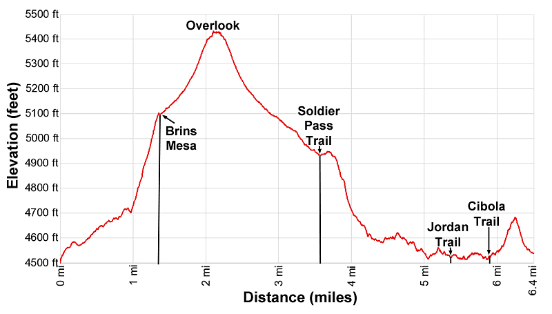
Elevation Profile
Driving Directions
The Brins Mesa – Soldier Pass Loop is composed of four trails; Brins Mesa, Soldier Pass, Jordan and Cibola. The loop can be started at the Jordan Trailhead (Brins Mesa/Jordan/Cibola trails) or the Soldier Pass trailhead (Soldier Pass/Jordan trails).
The Soldier Pass parking lot, open from 8 a.m. to 6 p.m., only has space for 14 cars. Overflow parking is located 0.5 miles from the trailhead along the Soldier Pass Road. Signs clearly mark where no parking is allowed. Once past the signs you can park. Cars typically start lining up well before 8am in hopes of getting a space.
The Jordan trailhead is a much larger parking area without time constraints. I strongly recommend using the Jordan Trailhead for this hike. If you wish to visit Soldier Pass Cave first, walk clockwise starting at the Cibola that leads to the Jordan trail which connects with the Soldier Pass Trail. Total distance to the Soldier Pass trail is about 1.0 mile when walking this direction.
Driving Directions from Sedona to the Jordan (aka Jim Thompson) Trailhead: From the traffic circle at the intersection of Arizona 89A and 179 head north on Arizona 89A for 0.3 miles to a traffic circle. At the circle, take the third exit onto the Jordan Road. Follow the Jordan Road for 0.8 miles and then turn left onto West Park Ridge Drive. Drive 0.7 miles to the Jordan / Jim Thompson Trailhead at the end of the road. The road will be paved for the first 0.2 miles to a cul-de-sac. Drive through the cul-de-sac and then continue on a good dirt road to the trailhead. This lot does fill so get an early start.
Note: a Red Rock Pass, America the Beautiful Interagency Pass, Golden Age Pass or Golden Access Pass is required to park in the lot. Red Rock Daily passes are $5, weekly passes are $15 and annual passes are $20. There is a machine at the parking area to purchase the pass. The passes can also be purchased in many shops around Sedona or online.
Driving Directions from Sedona to the Soldier Pass Trailhead: From the traffic circle at the intersection of Arizona 89A and 179 head west on Arizona 89A for 1.25 miles and then turn right onto Soldiers Pass Road. Drive 1.4 miles and turn right onto Shadow Rock Drive. Follow Shadow Rock Drive for 0.25 miles and then turn left onto Forest Road 9904. Follow FR 9904 for 0.25 miles to the parking area. (Note: Shadow Rock Drive will cross Rim Shadow Drive. FR 9904 is the first left after Rim Shadow Drive.)
The parking are only has room for 14 vehicles. Length restrictions apply. Overflow parking is located 0.5 miles from the trailhead along the Soldier Pass Road. Signs clearly mark where no parking is allowed. Once past the signs you can park.
Note: a Red Rock Pass, America the Beautiful Interagency Pass, Golden Age or Golden Access is required to park in the Soldier Pass lot. Red Rock Daily passes are $5, weekly passes are $15 and annual passes are $20. Passes can also be purchased in many shops around Sedona or online.
Trail Resources
- Trail Photo Gallery
- Trail Maps
- Basecamp(s) Information: Sedona
- Region Information: Arizona's Red Rock Country
- Other Hiking Regions in: Arizona