North Molar Pass 
Distance: 14.4 miles (round trip)
Banff National Park, near Banff in The Canadian Rockies
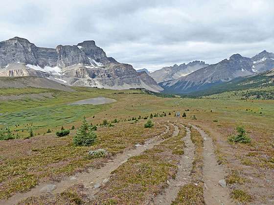
Looking back at Mosquito Lake
This scenic hike travels up beautiful Mosquito creek, ascends sprawling alpine meadows filled with wildflower and then climbs rocky slope to North Molar Pass where terrific views extend to the Bow Valley, Dolomite Peak massif, the Fish Lake valley and beyond.
See Trail Detail/Full Description
- Distance: 14.4 miles (round trip) to North Molar Pass
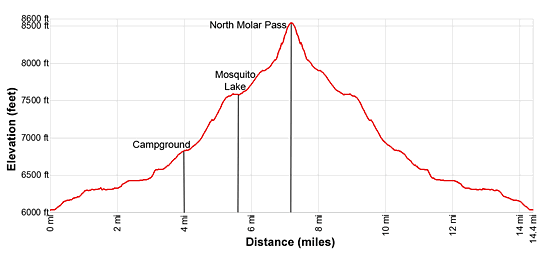
- Elevation: 6,025-ft. at Trailhead
8,497-ft. at North Molar Pass - Elevation Gain: 2,472-ft. to North Molar Pass
- Difficulty: strenuous
- More Hikes in:
Banff / Lake Louise / The Canadian Rockies
Why Hike North Molar Pass
The long, scenic hike to North Molar Pass (8,497-ft.) initially ascends along Mosquito Creek valley before turning northeast and climbing thorough extensive alpine meadows filled with wildflowers. Along the way pass Mosquito Lake and enjoy great views of Dolomite Peak (9,127-ft.) and Nosseum Peak (9,799-ft.). From the meadows, a steep climb up rocky switchbacks leads to North Molar Pass where far-reaching views extend west/northwest to a sea of peaks stretching from the Bow Valley to Dolomite Peak and Watermelon Mountain. To the south, Molar Mountain towers above the Fish Lake valley.
This hike is the first segment of the backpacking trip to the Fish Lakes and the Pipestone Pass area. Permits are required to camp in the Banff Backcountry and advanced reservations are recommended due to high demand.
Elevation Profile
Trail Resources
Trail Detail/Full Description / Trail Photo Gallery / Trail Map
Basecamp(s) Information:
Banff / Lake Louise
Region Information:
The Canadian Rockies
Other Hiking Regions in:
Alberta / British Columbia